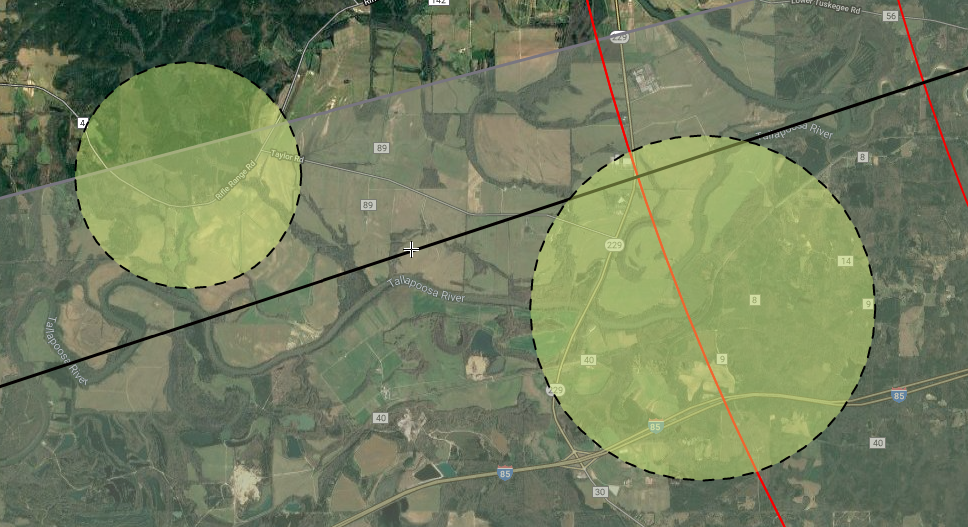
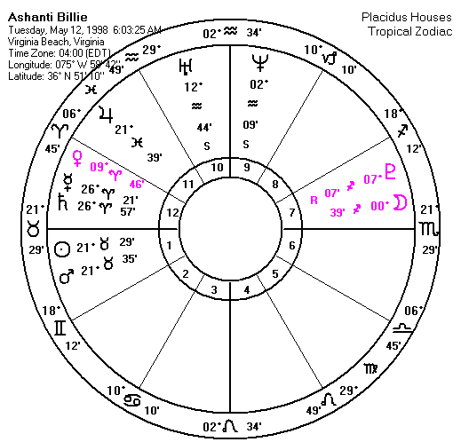
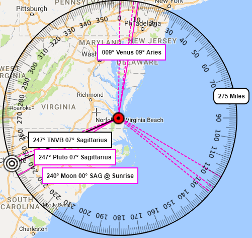
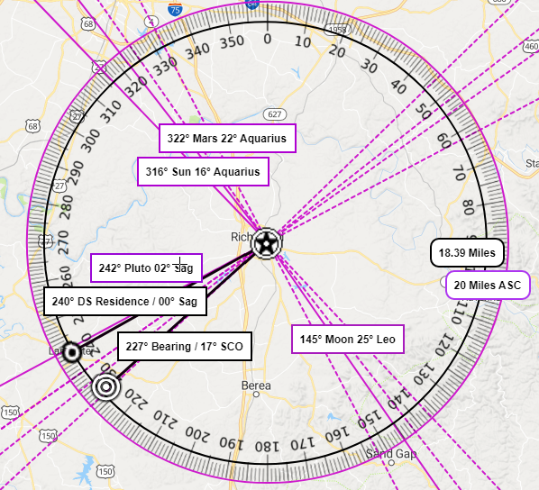
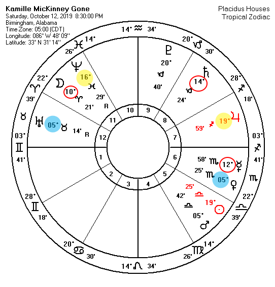
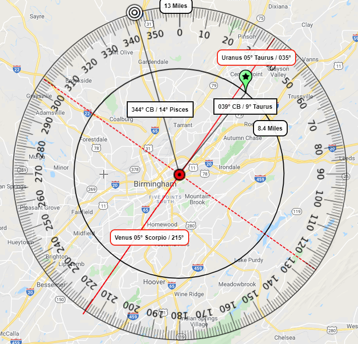
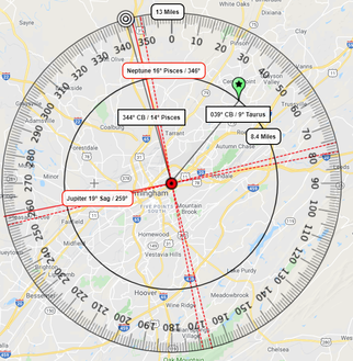
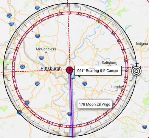
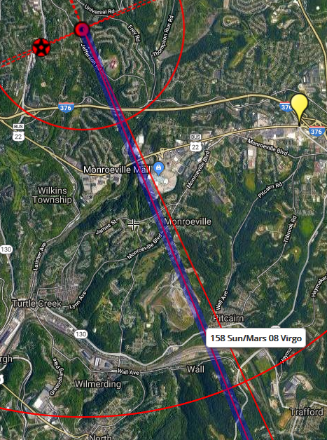
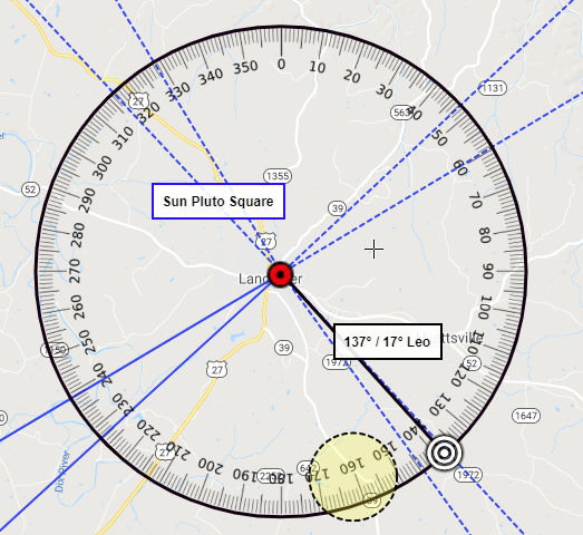
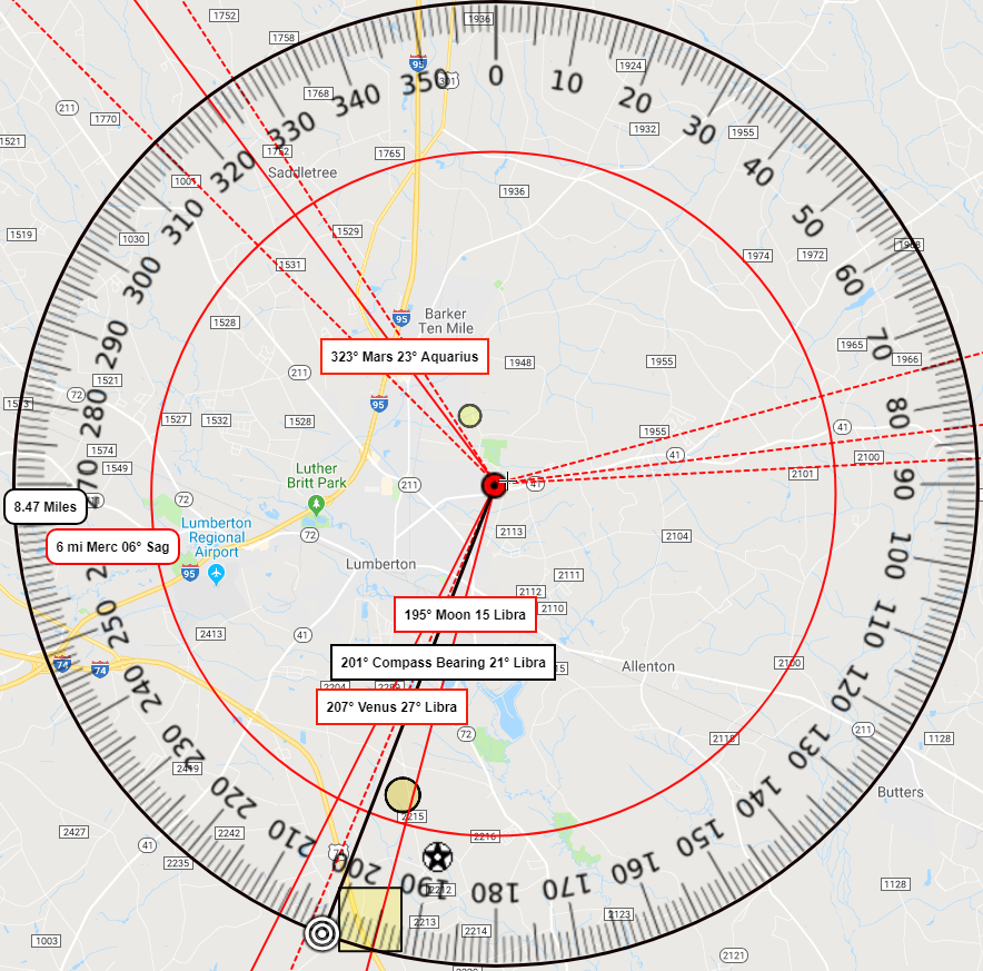
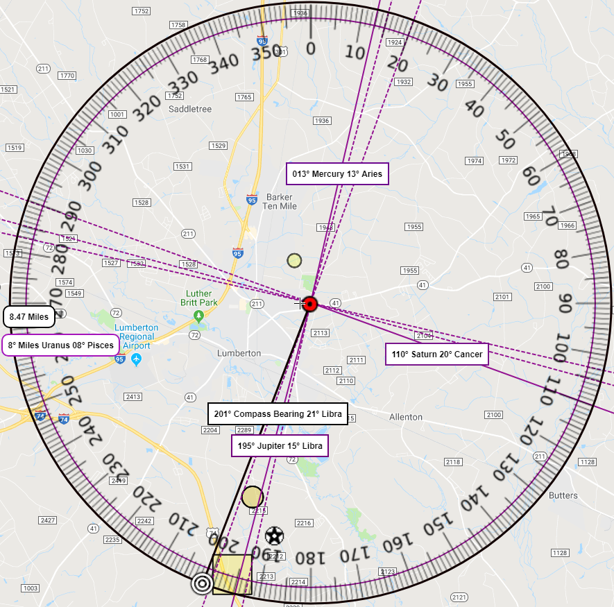
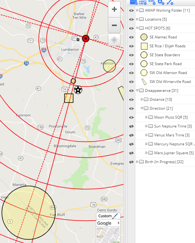
In the map above, illustrated with blue lines is Sebastian's SunMarsMercury TSquare to the planets Saturn and Uranus vectored over his home and moving out over the terrain into the surrounding area. The red lines illustrate the MoonNeptune Opposition that was culminating from early Sunday, February 25th up until the time when the Moon was complete from opposing Neptune when he was reported missing. A link to his interactive map erected on his behalf will be given at the end of this writing.
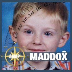
If you need a little shove into the idea of how powerful our stars are when we are born. Let me explain that Sebastian at birth had both his Sun and Mars measure the 15th degree of Sagittarius which are the same numeric digits that are appearing as the age of his mysterious disappearance, 15. Not only that, ... ...his natal Mercury measures (at sunrise) 22 degrees of Sagittarius; which in total degrees of celestial longitude can be expressed as 226 degrees; which can become the date 2/26 for when he was reported as missing. His Sun Mars and Mercury are all operating together while they all tangle in the squaring aspect (90° angle) they make to the planets Saturn and Uranus at his birth. Something sudden (Uranus) and Debilitating (Saturn) occurred on 2/26 at the age of 15 for SEBASTIAN ROGERS. Uranus is also the planet that us stargazers give rulership over to the railroad, while Saturn and Jupiter are the two planets I consider to be those to rule over Bridges. Ever since Saturn moved into Pisces early March 20, 2023 I've been concerned for our Bridges here in the United States. Now I'm concerned for a bridge in the matter of SEBASTIAN ROGERS. Also hiding inside the name SEBASTIAN ROGERS is the word TREASON. If you anchor the word TREASON , which means an act of deliberate betrayal, it sort suggests to me he was deceived somehow. When I anchor the word TREASON, I can rearrange the rest of his letters into the anagram BASE RIGS TREASON. What BASE RIGS TREASON? Could it mean, "home" BASE? I know what your thinking? His name is, SEBASTIAN WAYNE DRAKE ROGERS.
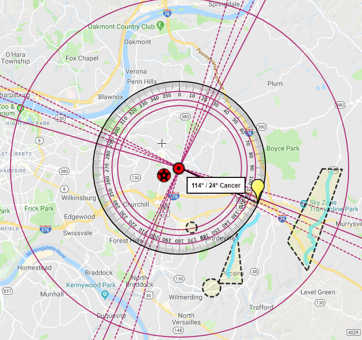
Yes, I know. It too is very telling. YES! SON SANK BRIDGE WATER AREA. Or could we write it as YES! SANK SON WATER BRIDGE AREA as each of them are anagrams of SEBASTIAN WAYNE DRAKE ROGERS. So, either way you want to say it, it's a disturbing phrase of words belonging to a boy that has been missing for what is developing into three months already as of this writing. Also disturbing to find was YES! SNEAKS A RARE TOWN BRIDGE. A RARE TOWN BRIDGE? Makes me think of the railways and the bridges trains use to move over water. These types of bridges certainly don't get the traffic a regular road bridge sees every day. Could that be what's RARE about this BRIDGE? Think, Hendersonville folk. Think. Which of your bridges moving over water, whether for car or rail, could be accessible under the cover of dark, and have something RARE about it? My question to those of you who are not stopping your search for Sebastian--- what could you read into this one ----YES! SNEAKS A RARE TOWN BRIDGE? What is rare about the Bridges in your area? If I'm correct and it is going to be a boat/sonar that comes across Sebastian, which of your rail bridges have water deep enough for a boat to meander? And can any of you wives start asking your husbands to get out there and start fishing? Sadly, search parties don't find the missing more than the public does on happenstance ---so let's go, get those boats out. Start stirring up the water. Sebastians stars are matching what is name is revealing. Bridges and water. You'll be glad to also learn that I found the word ARREST! Thank goodness. I found the words in his name to tell me YES, BAKE! ARREST WINDSONG AREA. So to me, the heat is on; and it looks like it goes all the way EAST into the Windsong area. So don't leave out any bridges heading along the way on roads that lead us to any area near WINDSONG. Just for good measure. The Sun and Saturn don't direct there at the time of disappearance, but the Moon Neptune opposition does---so something a bit hinky about the Windsong area which is just a jump south from Gallatin. Below is the link to Sebastian's interactive map with all potent aspects vectored over his residence and projected out to a radius of 75 miles that needs to be consider alongside the investigative intel coming to light. All hotspots are potent. All aspects, in each of their folders can be turned on and off for the viewing process and should be consider separately.
Time for Sebastian to come home. This writing will be updated as necessary so be sure to check back in.
1 Comment
Update: REMAINS RECOVERED 2/20Audrii Cunningham's remains has been recovered from an area near Trinity River Bridge and Rt59. This is an area that would be exactly opposite to her own natal Mars Neptune conjunctions; as well as the sextile from her Saturn Pluto trine that is illustrated in the image below. Bullseye is temporary and not exact. I will add this little one to our study in time; but right now I just want to go cry in my bed. 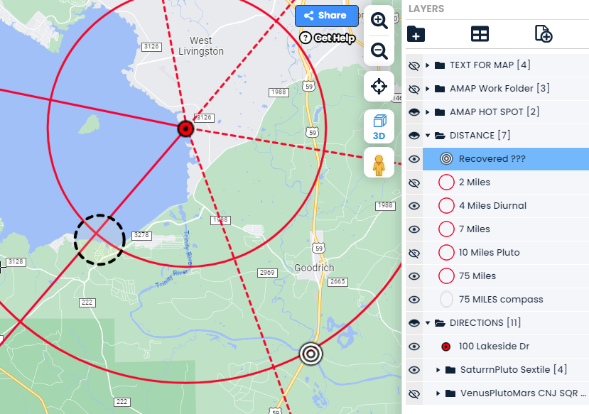 ORIGINAL POST 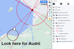 #MissingChild #AudriiCunningham Interactive Map construction and analysis for missing 11 year old Audrii Cunningham is incomplete, however this area near the Browder Marina off of Lake Livingston Dam Road is in alignment with the VenusPluto Mars Mercury Conjunction patterned as a Squared vectored over her residence. The whole pattern is potent, but the southwest arm of the planetary pattern heads a bit to the southwest of the Dam area where searching is taking place---this area needs to be checked. In addition,
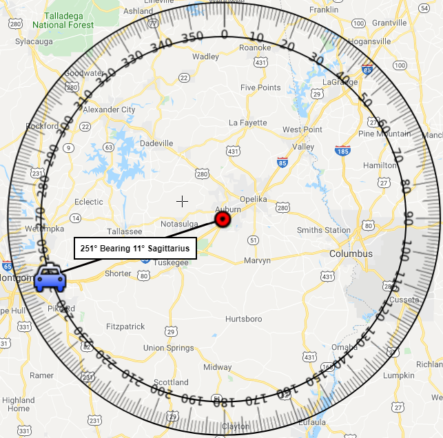
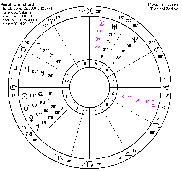
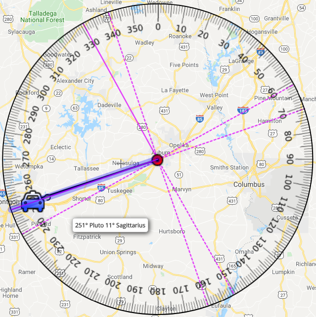
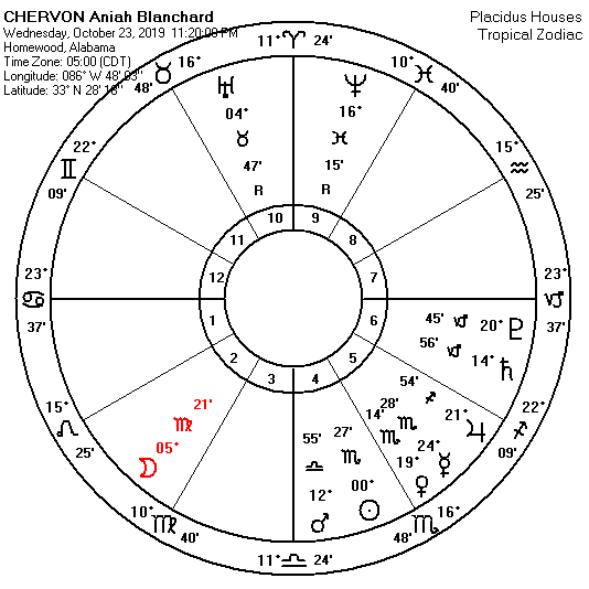
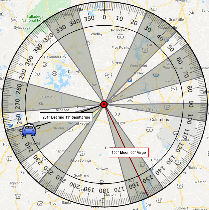
A check of the birth chart for the person of interest, McDougal, reveals this area would tie his own Natal Jupiter Square to this area, as well as his progressed Venus in square to Jupiter at the time of this disappearance. Born 12/3/81 puts McDougals' Sun at 11 degrees of Sagittarius, which measures 251 degrees of total celestial longitude, which happen to be the same numbers that appear as the date of Audrii's disappearance, 2/15 who was 11 years old at disappearance. Still waiting on a date of birth for Audrii to complete the analysis, but this area could hold promise for her whereabouts. If anyone comes across her date of birth please by all means post it in the comments. Updates in Progress as of 2/19/2024
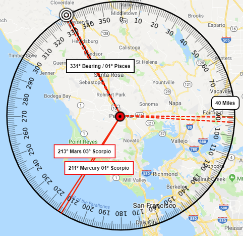
 Suzanne's recovered remains were found on September 22nd, 2023 some 34 direct SouthEast by South miles, as the crow flies, from her home. Below is the image illustrating the Sun Mercury conjunction in Square to Mars pattern that was present at the time of her disappearance aligning out to area where she was recovered near Maffat, Colorado. My sights were on this planetary pattern from the start but I was looking at the other end of the Sun and Mercury as noted by our Hotspots in the South West over the Sargents and Razor Creek areas. Right aspect, wrong arm of the Square. 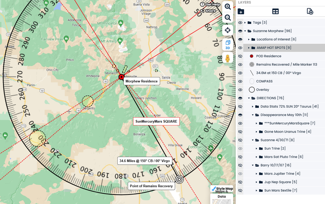 FOUND SAFE!!! 10/2 - Thank you, Jesus!
 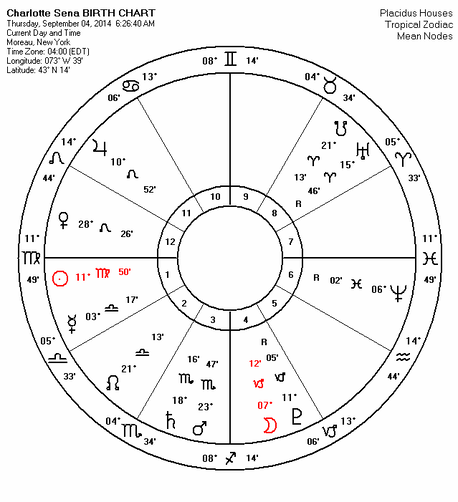 Charlotte's (9/4/2014) birth placement of the Sun and Mars will reveal a description of her abductor that I'll attempt to interpret below.
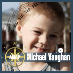
The Sun in Virgo in direct tight opposition to Neptune suggests someone who was either wearing a uniform and/or dirty work clothes and works with his hands. A fix it type person. A person that mostly keeps to himself--loner type. A thin build n medium to tall height. Possibly born in between July 22 and August 21st when the Sun is in Leo. Hair is curly or wavy and dark in color. Wore a hat. Hat could have an image of a horse on it, or is the logo for a surrounding farm. The MarsSaturn conjunction in Scorpio suggests there is a scar on the face or neck; as well as dirty clothes, and a slovenly appearance---sneaky quite type. The Virgo Scorpio connotation could very well suggest that he works as a laborer and/or works on the commercial type vehicles. The vehicle used could also not be his and belong to his employer, and the color of the vehicle is in the Tan/Brown family. Why was he there? Fix the bathrooms? Deliver? Service a camper? Was there something broken that needed fixing?  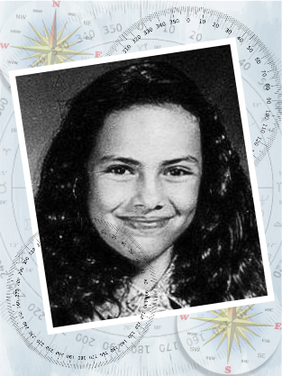 It has been some thirty years since child predator, Richard Allen Davis, acted upon his perverse impulse to conduct one of the ugliest crimes imaginable. Brazingly, Davis removed POLLY HANNAH KLASS right out from under the safety of her own bedroom while she was in the middle of enjoying a slumber party with friends. It was approximately 10:15 PM on October 1st in 1993 when Davis stole her to leave her for dead under PLANKS of PLYwood some 50 miles away from her home in Petaluma, California. There is reason why I put the word PLANKS and the letters PLY for PLYwood in bold captial letters. Words are very important in regards to the missing, as I will be explaining here in this writing. However for right now, know that ... The details of Polly's case is one of the reasons why AMAP keeps working to learn more about how to make whereabouts predictable by using the geometric angles offered by the measurable planets at the time of disappearance; Because there are children still missing and because America could of gotten Polly back ---shaken, but alive. 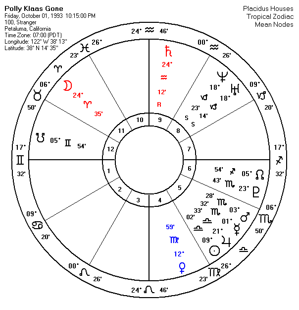 Petaluma's All Points Bulletin on Polly's abduction didn't span the miles. Polly was tied and gagged in the brush nearby while Sonoma County Deputies detained her killer on private property for trespassing on Pythian Road. Petulama Police kept the APB (All Points Bulletin) local; So the Sonoma Country deputies weren't aware that someone just snatched a child from her home an hour earlier out of another Sonoma County town.The Sonoma Country Deputies didn't have a reason to take a more in-depth background peek at the man with his Pinto stuck in a ditch. I learned in the first line of the third chapter of Barry Bortnicks' book, "Polly Klaas: The Murder of America's Child" that it was 24 driving miles from Polly's home on 4th Street in Petaluma to the intersection of Route 12 and Pythian Road where Davis embarked on private property with Polly in tow. I found these details interesting to cite, because at 10:15 PM on October 1st in 1993 both the Moon and the planet Saturn were both measuring 24 degrees of their respective zodiac positions, Aries and Aquarius. While Venus in Virgo measured 12 degrees---which is the vectored compass bearing I measured from Pollys' home to the intersection of Route 12 and Pythian Road. In the image below, I illustrate the intersection of Rt. 12 and Pythian Road. By the way, all the letters that make up the name PYTHIAN can be found in Pollys' full name, POLLY HANNAH KLASS, except for the letters t and i. The black line in the image below that you see running over Rt. 12 is the vectored measurement I drew from Polly's home to illustrate a 24° compass bearing offered by the Moon at 24° of Aries and Saturn at 24° Aquarius. The Moon and Saturn measuring 24°'s of their respective sign signatures were considered to be exactly SEXTILED which I believe increased the vibration of the number 24 that gave us the distance in miles when police could of gotten Polly back alive; if only that All Points Bulletin could of spanned the miles. 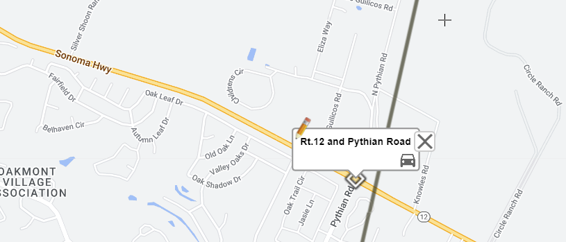 If an All Points Bullentin on Polly's abduction was extended becasue the stars said she could of been that far, the radio alert could of been heard by those Sonoma County Deputies. I think about those deputies all too often. My heart and mind aches for them both. Because I know that they eventfully learned they didn't have the knowledge they needed to save Polly when she was right there beside them gagged and hidden in the nearby brush. This is a terribly disturbing fact. It is my intention in this writing to disturb you with other parallels like Polly's but with more of a focus on the perception of word Syntax in the matter of the missing; and what is hidden in the names that belong to them and vibrate out into the universe. Anyone can do this if you can listen closely with an inner ear. I am sharing this information because I believe it could persuade readers into considering a new way at looking at the predicament of a missing child or adult. Why shouldn't we consider new perspectives when it comes to this heinous crime being committed against our children? We will return to Polly Klaas later in this writing. But first, let me continue to talk Syntax and the names that belong to the missing.  As of this writing, five year old Summer Wells is still missing out of Beech Creek, Tennessee. She was alledgely last seen by her mother and reported missing to police at 6:32 PM on June 15, 2021 from their residence at 110 Ben Hill Road. An interactive map has been shared on her berhalf. To date, Summer Wells' parents have taken a public beating about her disappearance. I mulled over the sound syntax from the letters of SUMMER WELLS' name, it can tell me quickly, LM LURES ME SW. Could the letters L and M be standing for Lawn Man or Men? Sort of gives me the feeling of a man on their property or next to their property? Perhaps Summer is familiar with him? Could someone Summer knows have been waiting in the nearby SW brush to LURE her away? I think its very possible. But what happens to that idea when we anchor the words LURES ME with her middle name SUMMER MOON WELLS. I found MOM SLOW, MEN LURES. MOWER'S SON MULL ME. SON MELLOW ME RUM. What happens when we look at this idea through the lens of the name SUMMER MOON UTAH WELLS? HMM, OUTLAW SON LURES ME. METH RUNS US ALL, MOM OWES. The other clues her name lend are so disturbing to me that I don't even want to write about them here. Everything I found supports that Summer was a victim of the people in her immediate circle and the surroundings, that includes her parents and the people they know. I even took a look at Summers' home address ONE TEN BEN HILL ROAD. Yes, you can syntax addresses too. YES, SWEET MONSTER EATS THERE is an anagram of ONE TWENTY THREE SESAME STREET. Sadly however, ONE TEN BEN HILL ROAD doesn't vibrate to anything positive when syntaxed. The family of children words that could be made with its letters ONE TEN BEN HILL ROAD are immensely thought provoking and stomach turning when you think about the fact that an innocent young child has gone missing from that property. They are . . . EERIE, DON, DELIBERATE, LETHAL, INBRED, DEALER, LOAN, HOTEL, BAR, BORDELLO, BROTHEL, BANDIT, TABOO, HARLOT, LIED, LIAR, LOANED, RENT, BLONDE, LION  Very troubling when you consider a beautiful BLONDE female is missing from this property. I also found the word HAIR. LET BLONDE NEON HAIR is an re-arrangement of the address ONE TEN BEN HILL ROAD. Here is a picture of Summer with neon pink coloring in her hair. Matter of fact, the address can tell us NOT NOBLER HEADLINE and BLONDE HEIR NET LOAN. Sounds to me we are going to learn of some nefarious TRADE happenings taking place on this property by the people that live there; and I'm afraid they include Summer. Most of what I found in this word string ONE TEN BEN HILL ROAD where there is a missing child would turn your stomach. I'm only sharing a small portion of it here with readers. Read the last three words in the group above and know that ONE TEN BEN HILL ROAD rearranges into HE RENT A BLONDE LION. Summer Wells went missing on June 15th, 2021 while the Moon was in the sign of the LION, LEO. The Moon was sextile to the Sun in Gemini. Keywords here are Man/Father (Sun) in the family or neighborhood (Gemini). It makes me ill to think she may have been traded for money or to satisfy a loan. No accidents. No strangers. DELIBERATE. TABOO.  One month and two days later, out in Fruitland, Idaho on July 27th, 2021 at approximately 6:30 PM little five year old MICHAEL JOSEPH VAUGHAN vanished walking away from his SW 9th Street neighborhood. Again, as of this writing, Michael is still missing. Moving around the letters from his name MICHAEL JOSEPH VAUGHAN they can be rearranged to make the words which can be syntaxed to tells us, OUCH! A JAG. HELP! ME VANISH! Those words are a complete anagram using all the letters of his name MICHAEL JOSEPH VAUGHAN. It sounds to me like his name is telling us that Micheal may have accidently gotten hit by a car or van. Perhaps the driver of the VEHICLE thought taking off with him was a better idea than getting him help. 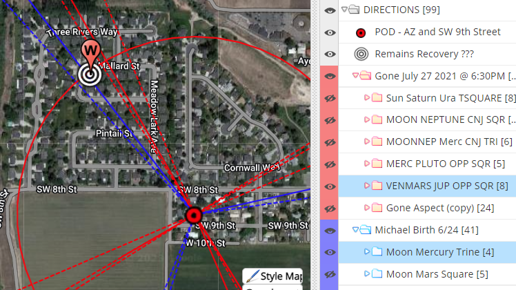 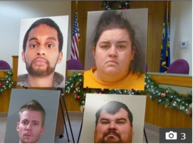 I'm really wondering what the police must know that we don't with the arrest of SARAH WONDRA who lives just a few blocks Northwest of Michael. The police were just recently digging up her backyard located at 1102 Redwing Street in an effort to find Michael. The map above reflects the locations of Michaels' home (red target) and the Wondra residence (bullseye). The colored vectors represent the planetary patterns present at his disappearance and birth pulling over to the WONDRA residence. The picture above is of Sarah Wondra, her husband Stacey, and two other males that were living in her house at the time of Michaels' disappearance; they are, a one Barndon Shurtliff, 30, of Kuna, Idaho. And a one Adrien Lucienne, 32, of Toledo, Ohio. The police have reason to believe those two men and Sarah and Stacey Wondra know what happened to Micheal. A more recent article by Jake Garcia of KIVI TV relayed that Fruitland Police has sent evidence to a DNA lab and believe Michael was "possibly killed, buried and relocated" from the residence shared by Sarah, her husband Stacey and perhaps these two other males. It is not hard for anyone to consider a hit-n-run scenario when you see that these following words are living inside the name string of SARAH AND STACEY WONDRA. CARS DESTROYS CRASHES DEATH SNATCH SON DEAD DECAYS
 Much further back in time, is the case of JENNIFER LYNN FAYE. It was a chilly night in November of 1989 when this sixteen year old female teen from Brockton, Massechuettes strangely just disappeared after hitting several neighborhood parties and has never been seen again. There are witness accounts that put Jennifer at several different homes with parties going on that night, yet none of the youthful 'in-crowd' in Brockton knows anything about what happened to JENNIFER LYNN FAYE. Stranger still is that her own best friend at the time, a gal named, KRISTEN BALBONI, according to Jennifer's family has shown not one ounce of interest into Jennifer's disappearance. Balboni has never even once attended the many annual candlelight vigils that have occurred over the 33 years Jennifer has been missing. All while still living in the same neighborhood and in the same house as when Jennifer went missing. A long chat with one of Jennifers' sisters also offered that Jennifer and her best buddy KRISTEN BALBONI use to like to play quarters together while drinking coffee brandy at each others homes. I thought it peculiar that this friend would remove herself so completely from Jennifers strange predicament of being missing. So I thought I'd take a peek at her name. It became of no surprise to find that the word TREASON living inside the name KRISTEN BALBONI. When I anchored the word TREASON left over were the letters that instinctively arranged into KIL TREASON, N I BB. I'm guessing that the two letters B and B stand for Best Buddy. It's terribly hard not to consider from this syntax string that Jennifers best friend knows something about what happened to Jennifer on the night of November 16th, 1989. Jennifer's case is so disturbing that I'm planning another at length writing on her case. What keeps me positive about Jennifers' case coming to a conclusion is that her friends' name KRISTEN BALBONI holds the word TRIAL. If I keep the word TRIAL as my anchor it leaves the letters left over that can make the word BONES. Think of it like this. It has been over 33 years since Jennifers' disappearance, so when she if found, it will be only the BONES that will be left of Jennifer. Now don't you find it eerie that Jennifer's best friend at the time of her strange disappearance has a name that can anagram into BONES IN TRIAL with the two letters left over being the initials of her own name Kristen Balboni? BONES IN KB TRIAL. I'm almost done with the writing I am doing on Jennifers case and I will share it when I'm ready. Wait until you read what else I found in the names of that "in-crowd". I'm positive the truth will finally be forthcoming for Jennifer Lynn Faye. But for now, I'm going to continue to introduce you to the perceptions of Syntax using the words that can be born from the letters of names from a few solved cases, and also share what planetary patterns pointed to where they were found. But first, let us talk about the Power of Sound. The Power of Sound
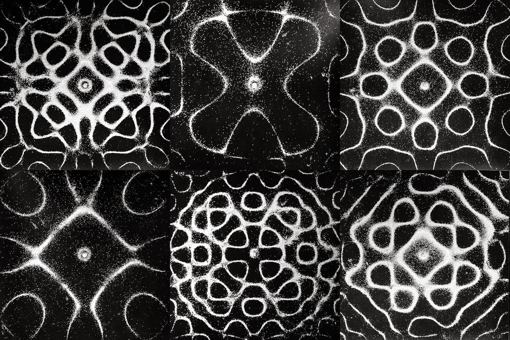
Please look at these two images for a minute. They're illustrations of how matter can shape itself when a set tonal vibration is cast. You'll see that they form geometric shapes. Lots of experiments are being done today in medical science with sound to heal the body. In addition, here is a good article on the topic of sound from ScienceFriday, called Seeing the Patterns in Sound. Whether you read it now or later please also consider taking a moment to watch this short TED TALK video below. You'll have a base understanding in whats termed, Cymatics. Cymatics is simply visualizing sound. This is sort of what I do when I scry a missing persons name.
Using some solved cases I will show how a stringed syntax of words that could be born of missing persons name, but constrained within the rules of anagrams, offered its wisdom to show how it bore impact on their predicaments and their whereabouts. Let's ease into this illustration with an introduction using some familiar, but rightly interesting words, anagrammed for truth. An Introduction To Syntax With Anagrams You should already know what constitutes as an anagram. If you’re not familiar, an anagram is a word or phrase spelled out by rearranging the letters of another word or phrase, such as the word LONGITUDE ---which can rearrange into the word phrase, TO INDULGE. In the 15th century finding Longitude was such a big problem for seafarers that the English Parliament offered a hefty prize to anyone who could solve the problem of determining longitude at sea. AMAP uses the word LONGITUDE in our work consistently, because we are noting the planets celestial LONGITUDE as they are measured along the ecliptic at any given time to draw vectors of those measurements illustrating the major angles formed by the planets over terrain from the point of disappearance to the point of recovery. We do it, so that we can hopefully UNTIE THE GOLD of where the missing are located. UNTIE THE GOLD is another anagram for the word LONGITUDE. In our study on the remains recovery of the missing, we are finding that our missing our being found in the sacred geometry of the celestial cycles. Why else would the word LONGITUDE hold within itself the words, UNTIE THE GOLD. When you explore our case studies you will see we are illustrating the geometry of the planets' positions against the great circle/compass and showing you how it offered location of recovery. The word phrase, THE ALPHABET can re-arrange into THE ABLE PATH. We can’t communicate effectively in writing if we don’t know our alphabet. I always thought it was interesting that the word, LETTERS, can re-arrange into word TRESTLE which of course is a supporting tower that holds up a bridge. So it seems that our LETTERS of THE ALPHABET can be mighty in and of themselves, can't they? As a matter of fact, the word phrase LETTERS OF THE ALPHABET can re-arrange to tell us, THE BEAT FORETELLS THE PATH. The beat is sound and sound shapes into geometrics. What makes anagrams interesting and challenging is that you are constrained to use only the letters in the word, name or phrase you are seeking to learn more about; and you must apply creative thinking and imagination to scry what they're revealing. It's a meditative process. Anagrams can be silly, amusing and profound; and sometimes they are disturbingly uncanny. The word phrase itself, TWENTY SIX LETTERS tells us TERSE TEXT N SLY WIT. That is exactly what anagram enthusiasts set out to do when they play around with the letters contained with a word, phrase or name ---to tell the truth in short verse. Let's take a quick look at the name John Emil List.
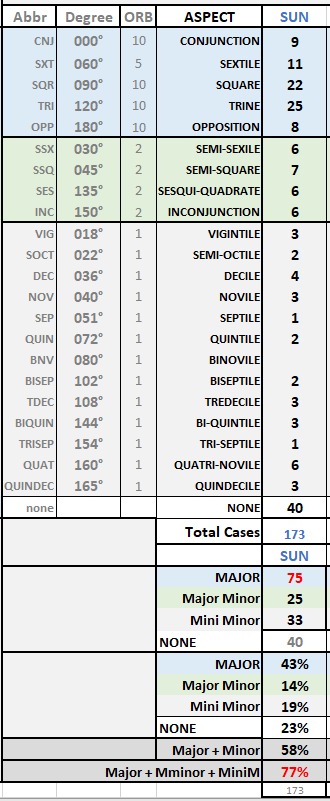
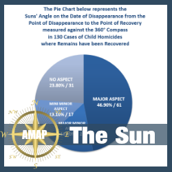
The letters of his name JOHN EMIL LIST can be re-arranged to foretell the death sentence he carried out on his family, in I STILL NJ HOME. The details of the John List case and the words in his name, are deserving of a writing all their own. It was here with this case where I got completely hooked on syntaxing the words in peoples names. But we will have to save John List for another writing. The word phrase MISSING CHILDREN can re-arrange into HIS L MIND CRINGE. The L stands for the Law, which as you know are the folks who are all too familiar with the ugly people bestow on one another. While the word phrase OUR MISSING CHILDREN tells us SUN LOR HIDING CRIMES! Yes!!! AMAP is trying to educate the public by illustrating how the Sun's gravitational pull, along with his other celestial pals, can offer us a direction to undo the hiding of our children who fall victim to this predicament. We are measuring COMPASS BEARING and correlating those measurements to the measurements of the planets at the time of disappearance and birth. 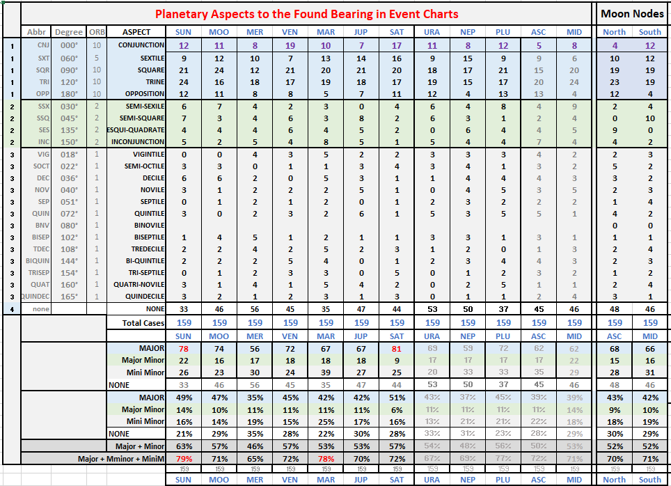 The image above represents the 159 cases of children in our study whose remains have been recovered. When the Sun's longitude was measured on the compass from their point of disappearance to point of recovery we noted what mathematical angle the Sun made to the found bearing. Using a standard orb of influence, the numbers are suggesting we just might be able to use the Sun's measurement in celestial Longitude as a predictor for whereabouts in future cases. While Saturn can help confirm it. But there is still lots to learn. So lets get back to sounds and syntaxes. AMBER ALERTS rearranges into BEST ALARM ER! and SMARTER ABLE. And lastly the word phrase MISSING KID can re-arrange into DIG, I'M SINKS. Now that is truley disturbing, because most often a child victim of homicide will either be in the water of a ditch, pond, lake, canal or river; or buried in a shallow earth grave or covered with brush in the woods. Either way we are digging through the murk of the other peoples' actions to recover their remains. If anagrams can distinguish these simple truths by twisting around letters into terse phrases about the subject of these words and word phrases that I just shared with you, why would it be inconceivable this strategy could offer something of value in the matter of someone who is missing right now? Of course not all missing kids are found expired, some come back home on their own. But what do we do when there is obvious reason to believe they won't be returning on their own? We have to search for our children. It's carved into our hearts to do so. This means we need some help' ---other than sound investigative procedure, I believe a little syntaxing of a missing persons' name is a method a law enforcement detective can add to their toolbox along with the help of the Stars. How cool is it to learn that the word phrase COMPASS BEARING when its letters are re-arranged can anagram into COPS BAG REMAINS. I consider myself a Syntax Detective. I dig for the potential clues vibrating from the sound frequencies of a missing persons' name to see what is possible and what could of shaped into matter. I've used this process to be successfully accurate in my work of predicting locations for remains recovery. It helps me to help others in their search efforts for the missing.
Now, Let's review some past case examples. And as we move forward, as already shown above, all letters and words in BOLD are part of the name, and makes up the clueful anagram. I will always tell you what letters are left over if the anagram is not complete. Remember earlier I relayed that it was my intent to disturb you with the perception of Syntax; but it is the heinous particulars of these crimes that are disturbing---I am only going to tell you how their name told the story. Case Study Examples Applying Syntax Of AnagramsIsabella Celis - Tuscon, AZ After six very long years we learned that CHRISTOPER CLEMENTS is the demon who stole little Isabel Celis. She too was taken from the safety of her bedroom on the night of April 20th in 2012. How apt is it that his name, CHRISTOPHER CLEMENTS can also spell out the unerring truthful word phrase, C MONSTER HITCH SLEEP? It's unerringly accurate, isn't it? ... because that's exactly what this CREEP did. It's right there hiding in plain sight of his own name, MONSTER CREPT CELIS with the letters H and H left over. I believe the two left over H's stand for Her Home. And the anagram can be read, MONSTER CREPT Her CELIS Home. When you think about how tragic this event really is, it should send a chill up your spine when you learn his name sends the message ---SHH, C LM, I'M ROTTEN CREEP. The C and the L and the M simply stand for Cee Little Miss. He was watching.
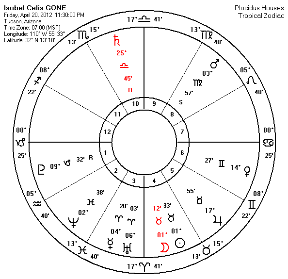
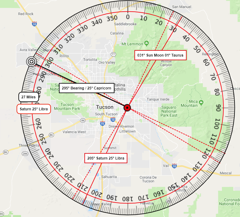
AMAP has added little Isabella Celis to our child case studies. Isabella was found 5 years after her abduction 27 miles away in an area outside of Tuscon that squarely aligned with the SunMoon Saturn disassociated opposition that was occurring on the night of her disappearance. If we add Saturn's 25 degrees together with the 1 degree of the Moon and the 1 degree of the Sun it will equal the 27 miles in distance to the location of her recovery. In the image above, we show how that planetary patterns position on the compass offered the direction to the location (the bulls eye) of her remains recovery. On September 14th, 2018 at 2:32 PM the Superior Court of the State of Arizona handed down an Direct Indictment on CHRISTOPHER CLEMENTS for his heinous crime against Isabel Celis. Its was a good day for law enforcement. Again, it is my intent to disturb with these details. I wanted you to see how clearly evident the sounds of this monsters' name had its own story to tell. Mollie tibbetts - Brooklyn, Iowa
Below is a compass set over a map of the area with the red target over the home where Mollie was dog sitting and left to go jogging. The white Bulls Eye is where she was recovered South East of the red target/the Point of Disappearnce (POD). The distance from the point of her disappearance to the point of her recovery measured 9.1 miles. Her name told us, CITE BI BAIL, OCTET MILES. The word OCTET means eight (8). Her name was telling us that she would be near this distance of 8 miles of where something to do with BAILS is located. Bails of hay are found on farmlands. The planets Mercury and Jupiter in their Square angle at the time of her disappearance when measured against the compass foretold that one of the directions involving this Square could perhaps prove fruitful for her remains. The yellow highlights in this map are our hot spots for potential whereabouts when we constructed our Interactive Map on Mollie behalf. 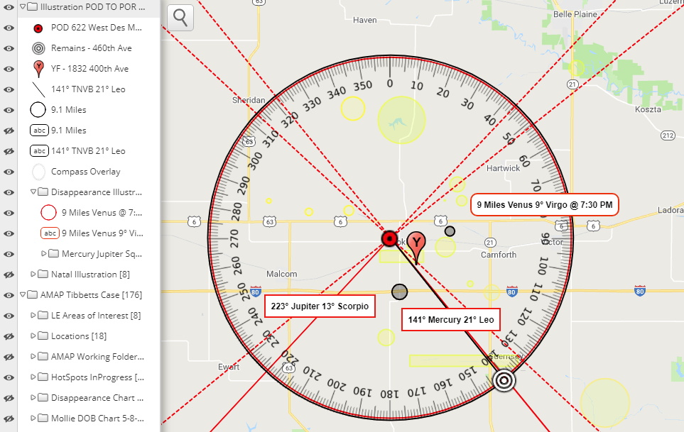 Mariah Kay Woods - North Carolina
The bulls eye in the map below shows the area where little Mariah remains were recovered from a creek off SHAW Highway. The red dotted line you see is one of the vectors drawn to finish off a Square angle to the Moon and Neptune's conjunction at the 11 degrees of Pisces. Little Mariah was found just two ticks north of this finishing point. 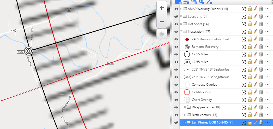 Timothy Wiltsey - Sayreville, New Jersey
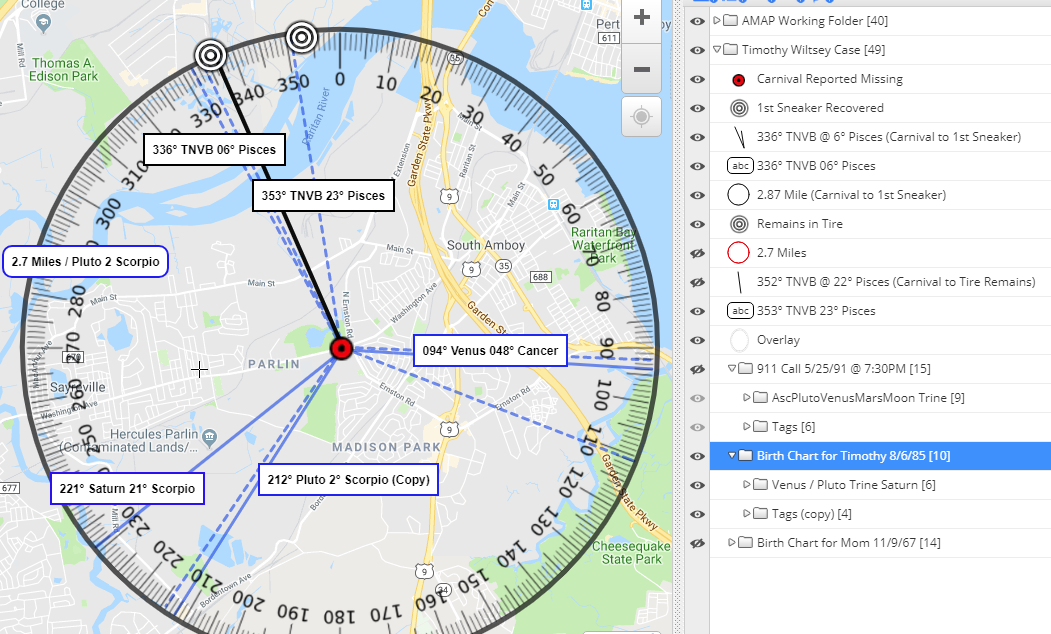 But it wasn't only his name that told he would be in SILT at a TWO MILE distance, the measurement of Pluto at 2° of Scorpio on the date of his birth offered this distance too. Yet, whats positively mind blowing is that when you see three of his birth planets vectored over the compass in the above map they point over to where he was recovered. His own Venus Pluto trining in their water elements at the 2nd and 4th degrees of Cancer and Scoprio had their finishing points pulling into those Pisces directional degrees on the compass into the area where his first sneaker was recovered, and his Saturn vectored over to where they found his partial remains in a truck tire along with his other sneaker. He was found in the silt spilage of the Raritian River. T! MY WITTILY SHOE is a very uncanny and eerie re-arrangement of the letters in the name phrase of,TIMOTHY WILTSEY, as it was the find of his shoe/sneaker that prompted the action to his recovery. His name, TIMOTHY WILTSEY can also be written as the truthful statement about the environment of his remains, O MY! I THY WET SILT. Jessica Ridgeway
AMAP did not work on little Jessica's case when she went missing. However we are using it as a case study to support our purpose to learn and predict location for remains. The Trine measurments involving the Sun, Moon, Jupiter and Saturn on that day she disappeared aligned their way to Siggs' residence; while Pluto's measurement at 7 degrees Scorpio offered the .7 miles in distance. This is where he dismembered her. (See Map Below) It's also interesting that I came to learn how his name, suggests to us that there was a moment when AUSTIN REED SIGG can also sound like E! DISGUSTING ERA. Yes, Austin! What you did to Jessica was disgusting. AMAP is using what you, AUSTIN REED SIGG did to Jessica to SEE GUIDING STAR. Yes Austin, something good needs to come out of what you did to Jessica. 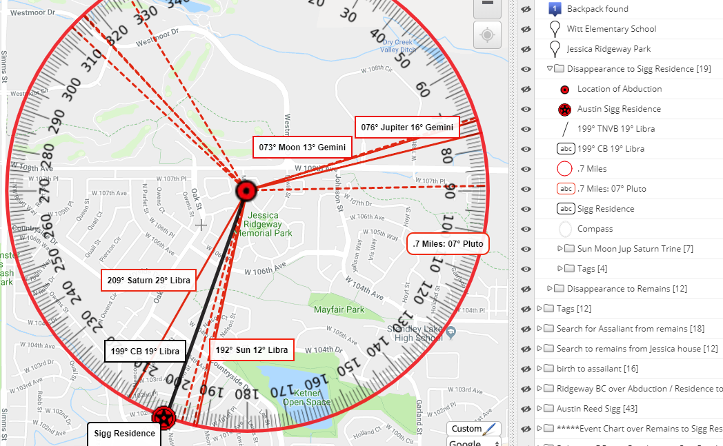 Christina Williams - Seaside, CA
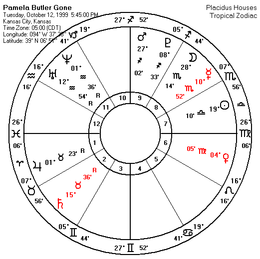
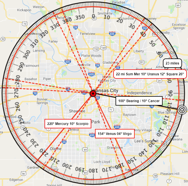
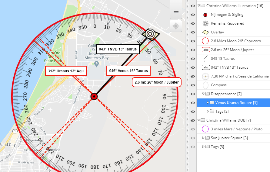 Sadly, the area where Christinas' scattered remains were found was previously searched but the exact location fell just a few feet short of the search efforts. CHRISTINA WILLIAMS holds within her name, the name CHARLS. We don't need to have the E to pronounce his name correctly; and with the letters left over, her name tells us a terse but chilling story---I'M SLAIN, I WIT CHARLS. Her name also re-arranges into THIS IS CRIMINAL LAW. In addition to the relentless efforts of Law Enforcement to get justice for Christina, one of the articles I read mentioned the delay in the trial is to prepare for a win at the death penalty for Holifield. Charles Holifield was sentenced to life in prison on March 24, 2020 for her murder. Just to satisfy your question of the name CHARLES HOLIFIELD, it perfectly tells us, I LORE A FLESH CHILD. Twelve-year-old Christina Williams disappeared while on a walk in her neighbor with her dog. Prior convictions in 1979 and 1983 included Holified attacking, strangling and raping two other teenage girls. It's quite maddening to learn he was ever allowed to leave a prison cell to go on a murder beautiful young Christina Williams. Pamela Irene Butler - Kansas City, Kansas
PAMELA IRENE BUTLER holds the words E! I BANE RURAL TEMPLE (church) with another anagram I found, LE ABLE, TERRAIN ME UP. It wasn’t a hunter, or a dog walker, or hiker who found little Pamela, it was LE (Law Enforcement) on a good solid lead from a witness with the plate number that found its way to another witness who recognized the truck that we got expired little Pamela back in 3 days. LE is not always this lucky.
Savanna Greywind - Fargo, North Dakota
 Toni Marie Anderson - Kansas City, MO Recovered deceased, TONI MARIE ANDERSON out of Kansas City, Missouri is one of the cases that is helping our work here at AMAP to earn some trust among those who conduct search efforts for the missing. But most too often we see incorrect conversations and mentions in regards to our involvement in Toni’s case. So let me take this moment to be clear about our involvement. Team Waters is responsible for finding TONI MARIE ANDERSON using high tech sonar equipment. AMAP did not find Toni, we are only responsible for analyzing her case via the planets, and using their patterns to create the interactive map that illustrated those patterns; And then from our experience we suggested to her search group four days after she went missing that the area where she was later recovered could hold promise for her whereabouts. Thats' it. But it wasn’t only the planets that led our attention to that specific area, it was her name TONI MARIE ANDERSON foretelling, ROAD NINE TO REMAINS. She was found in her car submerged in the Missouri River off of Route 9. Her name, TONI MARIE ANDERSON, held within it exactly where her remains could be discovered in a straight forward, no nonsense and chilling anagram of her name. As a syntax detective, I'm not totally convinced Toni mistakenly drove herself into the Missouri River---but that writing is for another time.  Lucas Hernandez
So now, let’s see what the name EMILY ANN MARIE GLASS can tell us. She was Lucas' step-mother who finally fessed up to the location of Lucas' remains. Her name, EMILY ANN MARIE GLASS, hides within it the word REMAINS and MISSING. When we anchor the word MISSING, it offers YA! MISSING NEAR E MALL. The East Towne Square MALL is only blocks from their Edgemoor home where she reports Lucas missing. Interesting. If I anchor the word REMAINS it offers YE! GAIN SMALL REMAINS which to me was a good indication that Lucas would be recovered. Below is a map illustration of the point of disappearance to the point of recovery. It illustrates Emily Glass' birth stars offering the distance and direction to Lucas' recovery. Her name offered the distance, as well as her Mars/Pluto Trine measuring 18 and 20 degrees of their sign signatures; and her Moon ranged in measurement at her birth also offered the direction. Her own Venus at 1° of Cancer formed an exact square to the point of recovery. We have found from our study that it is often more than just one planet directing to the location.
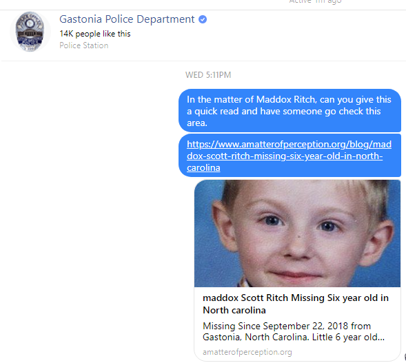
When you vector out the range of Emily's natal Moon for the day of her birth, (we did not know her exact time of birth) we find that she deposed of Lucas in a location that falls between the range of the Moons' measurement when its vectored over a map of the area from the point of their residence. While her Venus exactly squared the point of recovery. It was Emily's full name that was telling me to pay attention to her own stars to find Lucas. The truth to her crime was hiding in plain sight of her own name. While Lucas was missing, AMAP worked with several different independant search groups looking for Lucas. We shared with each of them, that Emily's name was telling us to pay attention to her Mars for the miles in distance and that they should look for roads that move over water drainage that are at least 20 miles out from the home and work inward. We even wrote up a syntax similar to what you are reading here that we forwarded to Law Enforcement. I wish they would of really considered the work. Maybe we didn't have to wait three months for Lucas' return? How hard would it have been to map out all the culverts under roads that are put in by the city and/or county? Maddox Scott Ritch - Gastonia, North Carolina
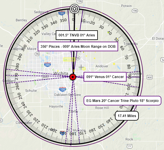
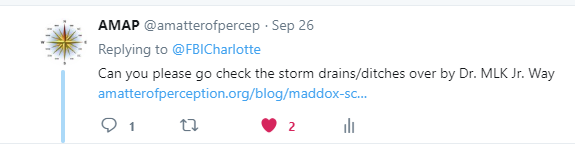
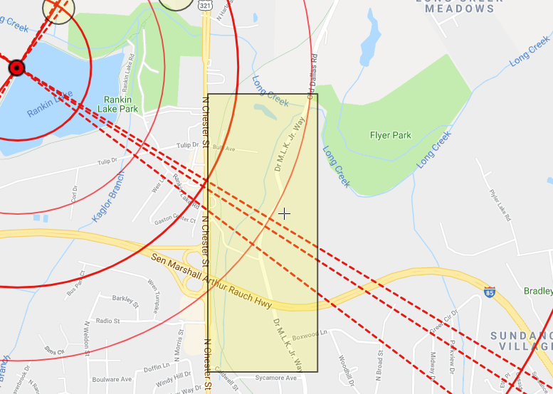
Then I found the word MARS and the words DOTS and I got an alarming feeling. These are two things that AMAP uses in our work. The planets measurements get solid lines, and their finishing points on the compass get dotted lines. So I'm thinking to myself, "Okay, this little one has something to tell me". So I began looking at the other end of Mars' measurement against the compass in his map (the dotted lines), and I saw there was a road called, Dr. M.L.K. Jr Way, which had a Long Creek running across it as well as South and North of it and it extended over by the park a mile away where Maddox was last seen. See the map below. This is the map I replied to the FBI Charolette Twitter post and the image I posted in our Blog Post to Gastonia Police Department on 9/26. Maddox was recovered on 9/27.  I wrote up a blog post and sent it over to both Law Enforcement division asking them to please just have someone go check the STORM DITCHes over by this road called Dr. M.L.K Jr. Way. I knew they were in the process of draining Rankin Lake, but I couldn't shake the finding of the words, MARS and DOTS; and then with the letters left over finding the words HID and TOT, ...now I was able to assemble all the letters to say, C X, C TOT HID MARS DOT. By now you should grasp that C is see, and the X is for MaddoX. I didn't care that this area was a mile away from where he was last seen---I didn't care that they were in the process of draining the lake. I thought with the Moon in Pisces at Maddox's birth that there stood of good chance he could be in the lake. But, I still wanted someone right than at that minute to go check the area I highlighted in yellow. I wasn't going to dismiss these words in his name telling me, X AT DOC STORM DITCH. Heck, Mercury measured 1 degree of Libra when he went missing. So we had a 1 mile radius drawn for this distance. And the radius too was falling over this Dr. M.L.K. Jr. Way. The map below actually shows the white target Bulls-Eye placed over the area of the road where law enforcement worked to recover his remains from Long Creek; Which of course acts a storm ditch during heavy rains. The red dotted lines are those representing the finishing degrees for the Moon Venus Trine against the compass that was in aspect at the time of his disappearance. So, to me, I'm finding that its pretty dang funny how a name works. It was the MARS word and its vectored lines that brought my attention over to this Long Creek area; but then it turns out to be a totally different planetary aspect that aligns perfectly to where he is found. Honestly, I never really know how my work on a missing persons name is going to play out, but I keep at it because it hasn't failed me. 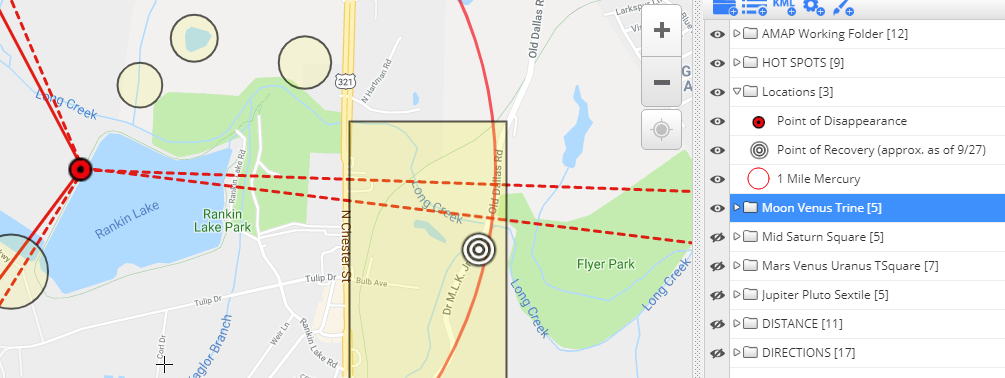
 In the case of Polly Klaas, the measurements of the planets at the instant of her abduction, were offering that exacting direction, at that exacting distance, at that exacting intersection of Pythian Road off of Route 12. How do you ignore that? You don't. You keep looking at other cases, to see if a pattern starts to emerge that can be trusted and made predictable and perhaps help get a child back, hopefully alive. Using Pollys' case in our study we vectored out lines on the compass surrounding Petaluma that illustrate the MercuryMars conjunction in Scorpio that aligned to the location of Polly's remains recovery by a finishing Trine some 50 miles northeast of Petaluma to Cloverdale. So the stars' told us where Davis was first detained, and then where he left Pollys' remains.  Its also the details of the Steven Stayner case that drives the work we do here at AMAP. Did you know that when little Steven Stayner was abducted from Merced, California there was a similar gut punching coincidence as was with the Sonoma County Deputies in the Klaas case? Steven's father Del Stayner drove out to Cathy's Valley where his father lived on the night of his son's disappearance to tell him about Steven being missing. It was learned in the book, "I Know My Name is Steven" by Mike Ecols who told us that Del Stayner was so close to the little red cabin where Steven was being held captive by Kenneth Parnell that he could of hit it with a throw of a stone. No father, anywhere, ever, should have to learn that their missing son was just a stone thrown away. Mercury at the time of Stevens disappearance in conjunction with a few other planets aligned out to the Cathy' Valleys area at the time of his abduction on December 4, in 1972.  I have my own guilt about Polly Klass, as silly as that my sound. When Polly disappeared I was trying to get Law Enforcement working the Sara Anne Wood case to consider a portion of the Adirondack Park Region as a possible area for a search effort. Sara Anne Wood is the harbinger of my interest in doing this work. If it wasn't for her disappearance AMAP wouldn't even exist today. Sara's disappearance was the first time I would cite a planetary pattern at the time of disappearance over the point of disappearance on a map and be correct in plotting an area of interest for Law Enforcement. By using a mix of the stars and the words in her name, Sara and her words along with her stars led me to accurately highlight the same area of the Adirondack Park Region one month after her disappearance. It wasn't until 4 months later when her killer was caught that he mapped out the same area to police as a potention place to plan a search for Sara's remains. Sara went missing in August of 1993. Lewis S. Lent was caught January 7th, 1994 after a failed attempt of abducting Rebecca Savarese. New York spent over 10 million dollars searching for Sara and she still remains among the missing today. Lewis Lent is doing life in a Massachusetts Correctional Institute. Another one of Lents' victims, little 12 year old Jimmy Bernardo was found and the details of his case are outlined here in our child study. It was interesting to learn, that while Sara was missing, one of the intentions for a 600 case 44 state children homicide study started in late 1993 and conducted by the State of Washingtons Attorney General (SWAG) inconjunction with the U.S. Department of Justice was;
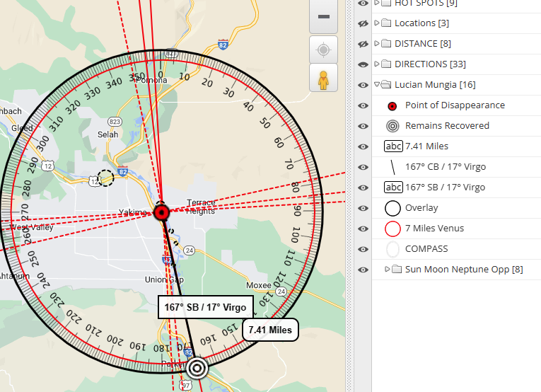
This except from SWAGs' study means that Law Enforcement needed help in solving these types of crimes. These words from SWAG compels me to keep trying to educate Law Enforcement and the public that we just might have the help in places we never thought to look. We just need to change our perspective. Today, AMAP is adding two more case subjects where remains have been recovered to our study. One child just arriving at a park for some playtime with family, and one adult just trying to get back to his friends. Both accidents. Both equally gut punching and heartwrenching. Lucian James Mungia will make our child study stand at 160 cases; while Brendan Thomas Santo will bring our adult studies to 103. Lucian James MungiaDate of Birth: October 5, 2017
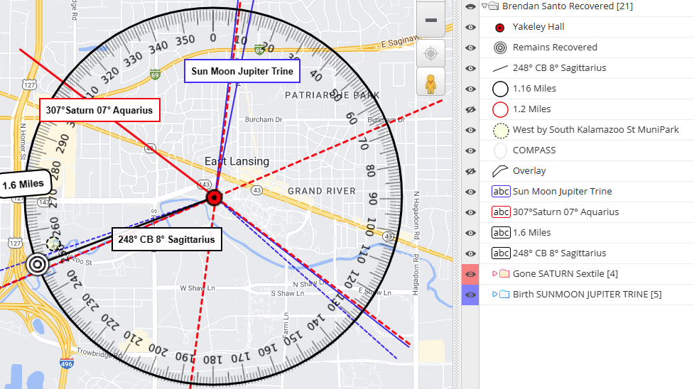
 Brendan Thomas SantoDate of Birth: April 01, 2003
Measurement from POD to POR
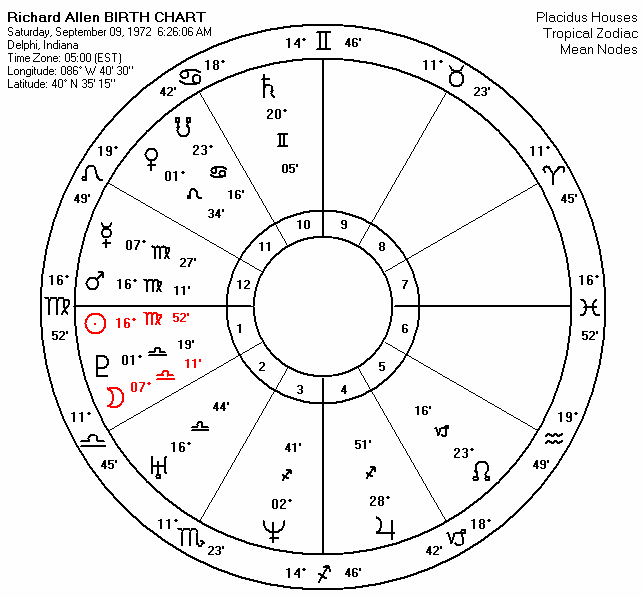
 AMAP is going to continue to allow these children and the details of their cases teach us whatever they can. Every one of the children, and adults, in our study gives us the confidence to reach out to Law Enforcement over and over and over again---hoping to help them with a quick recovery. 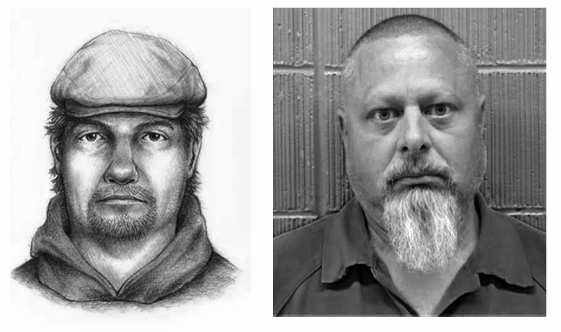 In Plain SightThe City of Delphi, Indiana had a population of 2,961 people in the 2020 census; and as it finally turns out, Law Enforcement with an arrest on October 28th is telling us, they believe one of them is responsible for the murder of 13 year old Liberty German and 14 year old Abigail Williams. After 2086 days have passed from the date of their heinous murder, we learn that a monster was literally lurking just right around the corner. This monsters' name is Richard Matthew Allen (DOB 9/9/72) and he work at the local CVS Pharmacy in Delphi. If you lived in the southwest part of the city you could easily just walk there to pay him a visit. This trusted monster was also known to play pool at JC's Bar and Grill, as two reporters wrote in their Indianapolis Star article which also revealed that friends called him "Ricky". The most terrible monsters always seem to lurk undetected as the people we tend to trust.
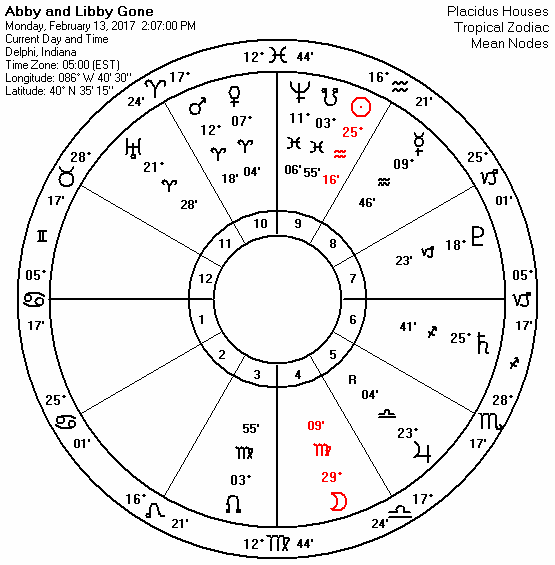
To be more exact, on the day of his birth, Neptune measured 02° (degrees) and 41' (minutes) of Sagittarius. Those numeric digits are the same digits that date his murdeous crime upon Abby and Libby, Febuary 14th, of 2017, which can otherwise be written as 2/14. To understand how uncanningly creepy that is---is to know that a day before his birth Neptune measured 2°40' of Sagittarius while the day after it measured 2°42'. More revealing is that his Venus, the planet that represents females and one's desires, its noted as being in the sign of Leo the sign that rules children. This aspect describes his perverted inclination for young females.  Point of Remains Recover to the Allen Residence. Here is another finding. The Sun and Mars at Allen's birth both measured 16° of Virgo. If we draw a vector from the location where the gals remains where recovered (bullseye) to his home (white target) where he lived at the time of crime, that bearing measures 17° of Scorpio, which means that his own SunMars conjunction in Virgo made a Sextile angle back to his residence from the point of his crime, and off by just 1 degree of being exact. The vectored bearing from his home to where he murdered the gals would be the exact opposite of 17° Scorpio which is 17° of Taurus. "Ricky" decided to play out his violent SunMars conjunction, which by the way was in Square to mean ole Saturn, at a location that is offered by the finishing points of a trine when those the Sun and Mars are vectored over the terrain from his point of residence. See the image below. 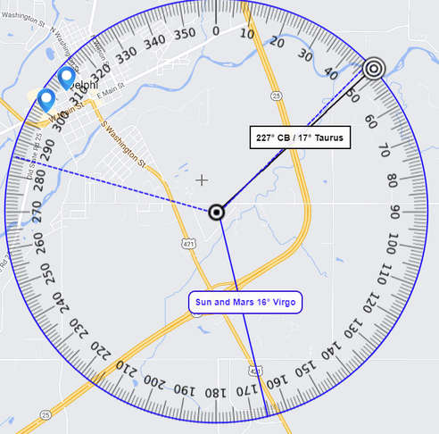 Point of Allen's residence to Point of Remains Recovery.
Furthermore, The Moon and Saturn are the two rulers of the Ascendant and the Opponent in the Disappearance chart. Saturn at the time of the girls murder was ruling the house of the opponent, the 7th, and just finished a square to the Moon, which was ruling the Ascendant, the victims; and the Moon was deposited in the 4th house of the community and neighborhood; while Saturn was deposited in the 6th house. The 6th house is house of health and service. Allen acted in his community as a person who provides the service of pharmacuticals that people use for health purposes. Ya gotta love Star Logic. Saturn also exactly sextiled the Sun; who had his rulership over the 3rd house of the surrounding neighborhood. This aspect also inclines to an older man, but tells us the opponent or "person responsible" would be connected to community as much as the girls were connected to the surround area. The girls weren't out of town visitors, they were locals as represented by the Moon ruling the Ascendant and deposited in the 4th house of the disappearance chart.
I personally always look to the Sun and Mars in charts of disappearances and charts of birth to find clues about a persons abductor. The Sun and Mars are the two celestial bodies considered to be male in nature and lean towards explosive violence. Using a time at Sunrise for the birth of Abby, we see she had her Sun conjunct Saturn in the sign of Cancer and both were trine to a MarsUranus conjunction. Cancer is that sign that rules over 4th house matters of the home and the home environment such as the surround community. So her Sun sign signature alone was offering an older male in the community. But only a chart erected for her exact time of birth could tell us more. Libby's birth chart isn't as easy to interpret. Her Sun at 5 degrees Capricorn is not making any real strong aspects with other planets. I'm worried that by looking at her chart it could be easy to think a stranger to the community was responsible being that her Mars is Square to Uranus. It's only by looking at more and more birth charts of victims of such crimes against the knowledge of whether or not they knew their abductor where one can get a more predictable system for furture cases. This is how you learn, and its good to be wrong more than once, as it makes you go back and take another look. Looking into the future ... It will be interesting to learn how Law Enforcement zeroed in on Richard Allen in the coming weeks and months. At the moment, we're glad to be able to go back and look at this man's birth chart and see how he acted on his stars and where he choose to act out his crime. Every solved case teaches us something new. We keep learning how all important the Suns' position seems to be in such cases as it was in this case.
We also learned from this case that the Suns' measurement, at the time when the girls met up with Allen, made a Square angle right back to his own residence. While the Sun Jupiter Uranus Saturn Sextile took us over to where he worked at CVS. Chart and Map Illustrations for this sighting will be posted for public review at our site under the Predator Studies tab in due time. AMAP is sure we can use the Disappearance Chart to offer locations for where an abductor lives; and this case helps to support that theory. For now, We will wait with the rest of you ready to learn more about what took place that got this day to finally come. God Bless Law Enforcement and here's to the justice that is about to be served on behalf of Abby and Libby. Peace be with you all. 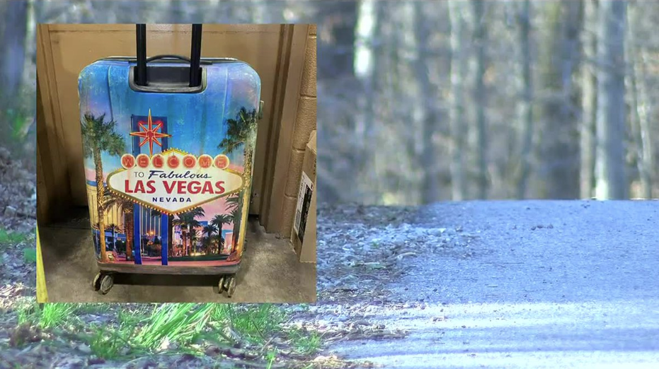 update 10/27/2022
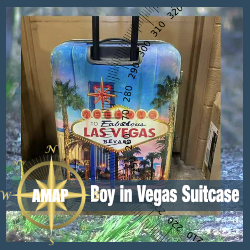
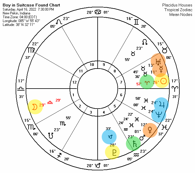 NEW PEKIN, INDIANA - The word phrase EAST HOLDER ROAD hides within itself the words TODDLER, DEATH, TRASH, DESOLATE, DEAD, HARLOT, DAD, DEALER, LEADS and ARRESTED. It's comforting to digest the last two words written, LEADS and ARRESTED; I'm hopeful we will see closure and justice for this unknown little one. Moreoverly eye-opening however, are seeing the first seven, TODDLER, DEATH, TRASH, DESOLATE, DEAD, HARLOT, DAD, and DEALER. Is the road actually telling us what we need to know about who put this little one in the woods to decay hidden inside a suitcase? To find out we will have to Anchor these key words for syntax. This writing will concentrate on a Syntax analysis for the name of the road, EAST HOLDER ROAD, to offer the possibility of minute details which otherwise might not be known to us---or to Law Enforcement. I will also take a peek at the planets positions for the time the suitcase was found, and for the approximate time when Law Enforcement believes the suitcase was left in those surrounding woods. If you are wondering if a street name can hold a truth, know that ONE TWENTY THREE SESAME STREET can rearrange into HEY! ENTER SWEET MONSTER ESTATE and N YET, SWEET MONSTER EATS THERE. I hope I don't have to show you a picture of the Cookie Monster to get this truth. Here's a more erie example, FOUR THIRTY ONE HILLSIDE AVENUE was the home of John Emil List. List murdered his entire family in November of 1979 inside this small mansion in Westfield called 'Breeze Knoll' before fleeing the State of New Jersey eluding capture for 18 years. It was his daughters' drama teacher Ed Illiano who illegally entered the house, perplexed by her absence from school, to hear the stereo blarring a classical music station while taking in the stench of rotting corpses as he ascended the basement stairs to the first floor. HAS ON HI-FI are a few words that can be found in the address string, FOUR THRITY ONE HILLSIDE AVENUE. It's what the letters that are left over can make that causes this address string to really be quite eerie. You see, List shot his wife and mother first after his three children John, Fred and Patricia left for school. Then he went on a few errands. One of those errands was stopping by the Post Office to have his mail held. U NO LETTER DELIVERY, U HAS HI-FI ON is a silly yet perfectly truthful re-arrangement of the text string FOUR THIRTY ONE HILLSIDE AVENUE. The John List story is a fascinating read. Even John's last name LIST can be anchored in this address text string to tell us, Oi! ONE HEAVY LIST LEFT UNHURRIED. Joe Sharkey in his book entitled, "Death Sentence: The Inside Story of the John List Murders" does well to chronicle the months, weeks and days both before and after this horrid mass murder event; as well as tell us John, UNHURRIED, slept the night in the house after the murders before leaving in the morning for Denver, Colorado. Let's get back to the boy in the suitcase on EAST HOLDER ROAD. I like to think Law Enforcement has got a good jump on this case analyzing the contents of the little boys stomach; the quality of his clothes; and maybe even tracked cell towers that picked up numbers that may not be so familiar to the surrounding areas during the beginning weeks of April 2022. The planet Mercury was in Taurus conjunct Uranus when the suitcase was found, thats information through technology. Mercury wasn't retrograde so there is no negative vibrational interference in regards to acquiring the information that gets this case solved. Accordingly, EAST HOLDER ROAD rearranges into RED HOT ARES LOAD. Yes, what they found there ignited everyone's attention. RED HOT ARES LOAD is interesting to this writer, because the Sun was 26° of Aries (ARES) in a mathematical 90° Square to the planet that astrologically rules the corpse, Pluto at 28° Capricorn, when this little boys' remains were discovered hidden inside a flamboyantly decorated suitcase dumped some 80 feet off this dead end route called, EAST HOLDER ROAD. O! HE'S A RA TODDLER is a quite eerie anagram when you know that RA was the Egyptian God of the Sun. The Moon was opposed the Sun while in Libra the sign of love or sexual relationships. The two celestial bodies that rule the two genders, Male and Female, were in an opposition aspect. The Moon is feminine. The Sun is Masculine. One would have to garner from this aspect that its highly likely a man and a women are involved in this case---but it doesn't necessarily mean they were together when this boy was left in the woods. The Sun at this event is also sextile to Saturn, it is separating, ---but remember, the suitcase was left there in the woods about a week prior to it being found. So the Sun at that time would be applying its sextile to Saturn. Sun Sextile Saturn applying would suggest a man of some age, I'm guessing under the age of 35, but not a young male in his early twenties. However, the Sun Sextile Saturn separating could very well be describing the older man who found the suitcase on his property while mushroom hunting. There are a few more interesting aspects happening at the time the suitcase was found that I will discuss throughout the writing. EAST HOLDER ROAD also tells us AH! TODDLER AROSE and AH! A SORE TODDLER. Yes! We learned from the autopsy that when the boy was put into the suitcase he was sick. Keeping the word TODDLER anchored, I also found SARA HOE TODDLER. Now the word 'HOE' is slang for HARLOT which is another word hiding in the EAST HOLDER ROAD. Could the name SARA be a real name or is it directing us to female who might be considered as unreputable and perhaps trading this little one for money? I'm not sure. This is the anguish I am plagued with when I syntax for truth. It's leads me to ask more questions. But the word HOE in the anagram SARA HOE TODDLER could also be considered as digging out or removing troublesome weeds. A dead child in your company is as troublesome as its gets when there is a reason you couldn't get them help when they where sick. Could the HOE mean it was a female who brought him into the woods, or is the reason the boy never got help while sick? More questions. When I anchor the word HARLOT there are letters left over that can form the words that can make the anagram HARLOT ADORES ED and HARLOT DARED EOS. The stars are pointing to a relationship and so is the syntax. In Greek Myth EOS was the goddess of the Dawn with two siblings Helios and Selene---who where God of the Sun and Goddess of the Moon. EOS was married to ASTRAEUS god of the Dusk. Together they had numerous children who represented that which occurred during the union from Dusk til Dawn. Its also said that EOS was the consort of the god ARES and caused the jealousy of Aphrodite who cursed her with insatisable sexual urge. So EOS abducted various young men. It's starting to feel like something else besides this child is being hidden and that there could be various other players in the background from the sound of the words living and neatly constrained inside the word phrase, EAST HOLDER ROAD. Seems to be a undercurrent of sex and relationships. Now with the knowledge of sex trafficking to be so prevailant these days and pretty much taking over the drug business, its hard not to think of this as a possibility in the background of this child. Especially seeing how taking a sick child to the hospital would of been the right thing to do, unless of course you can't because some other nefarious findings will be made. It's been almost 3 months, no one anywhere is missing a little 4 year old black boy? That's disturbing. This little one has been off of everyone's radar. Neighbors, friends, teachers, doctors, social services, etc. Why? EAST HOLDER ROAD is a very odd place to leave a child to decay when you take arial peek at the environment. I'm inclined to think that only a young person would be attracted into buying a suitcase showcasing Las Vegas. And in thinking about that suitcase, sex trafficking and seeing the word HOTEL living hidden inside EAST HOLDER ROAD, I decided I should anchor it and see what it can tell us. 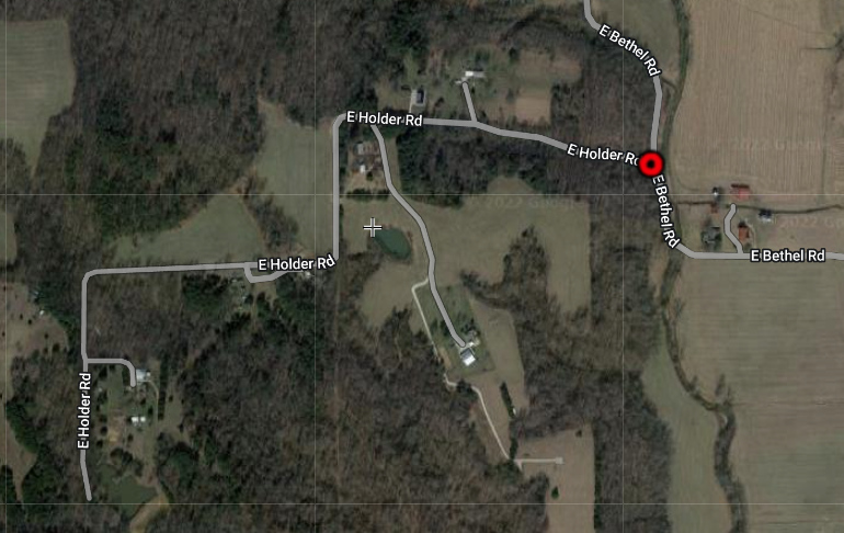 I wasn't at all pleased to see the letters left over could make the words DAD, ARES, and DEAD. I found the anagram A SAD HOTEL ORDER. OMG! Aren't HOTELS the places where such sex activities/relationships/trades occur? Places where people hide their affairs/sex acts with people who aren't the part of their marrige contract? Did something go wrong at one of the HOTELS in the area and this is where the little one passed, stuffed into the suitcase and then trashed? It's only a 40 minute drive from the center of Louisville into the area of EAST HOLDER ROAD. Or could the childs' mom be the one in the sexual trades business? I'm curious. DARE HOTEL ROADS is another anagram of EAST HOLDER ROAD and it certainly suggests that the person driving wanted to avoid heavily trafficked roads while a dead child was inside their vehicle. EROS is another god that is living hidden inside EAST HOLDER ROAD. EROS is the god of Love and was the son of Aphrodite. AHA! EROS TODDLER and HARLOT EROS DEAD. Sometime in April of 2022, someone or maybe some two someones, took a right or left hand turn off of EAST BETHEL ROAD to leave behind the remains of boy who we have learned died of dehydration via a viral gastroenteritis which causes vomiting and diarrhea. It was also reported that the boy looked as through he was cared for as he was clean and clothed. We don't know what color his clothes were, only that he was a black boy about 4 feet fall. It's assumed by this writer that a description of his clothes and a photograph of him are being withheld from the public to serve as a way of filtering through incoming leads. The one thing that could jog people's minds of this missing boy is being withheld. Why? What I found interesting to see is that the same words, RED-HOT, ARES and DEATH also hide within the EAST BETHEL ROAD text string as it does in EAST HOLDER ROAD. The complete word phrase EAST BETHEL ROAD can re-arrange into LOT BE ARES DEATH. Yes, indeed there was a plot of land off of this EAST BETHEL ROAD where a little dead boy was found in a suitcase while the Sun was in Aries. So what else can these two roads offer us in regards to this criminal act of leaving behind a little boy to decay in the surrounding woods? Let's see if it can tell us who left him there and perhaps from which direction they came. But first, as seen in the above arial image of EAST HOLDER ROAD there are only about seven homes scattered about it before it dead ends to what looks like a pond. I attempted to do a Google Map drive by, but its not available. Drat!~ I could very well be wrong, but this location doesn't scream 'unfamilar territory' to the someone or maybe someones that left this boy 80 feet off the road. I was thinking, did they want the boy to be found (flamboyant suitcase); Or, did they not want the boy to be found? Place him off of not one back country road, but two backwood country roads? Either way, I'm starting to believe that who ever left that boy in the suitcase has driven these roads before. Here's why. EAST HOLDER ROAD rearranges into DEALERS HOT ROAD. EAST BETHEL ROAD also hides within it the word DEALERS for a re-arrangement of A HOT DEALERS BET. Sounds to me someone running drugs or sex is using the roads to transport their goodies and these backroads keep them off of the major thorough fares in a reasonable but out of the way manner. However, that dang suitcase still has to be considered that it belonged to someone who may have been traveling. So one must considered the big surrounding cities to this location being
Or, maybe these DEALERS are there in the surrounding area and the suitcase is all they had to hide a boy who they were moving to his final destination. Maybe they are not dealing drugs or sex, but moves things around like TRASH removal or someone who delivers or sells a product. They were pretty comfortable traveling down EAST HOLDER ROAD to park the vehicle; take out a flamboyant suitecase; and walk into the woods without someone living there seeing. Heck, what was stopping them from just pulling over on EAST BETHEL ROAD and making the drop? Here's is what I found most interesting. 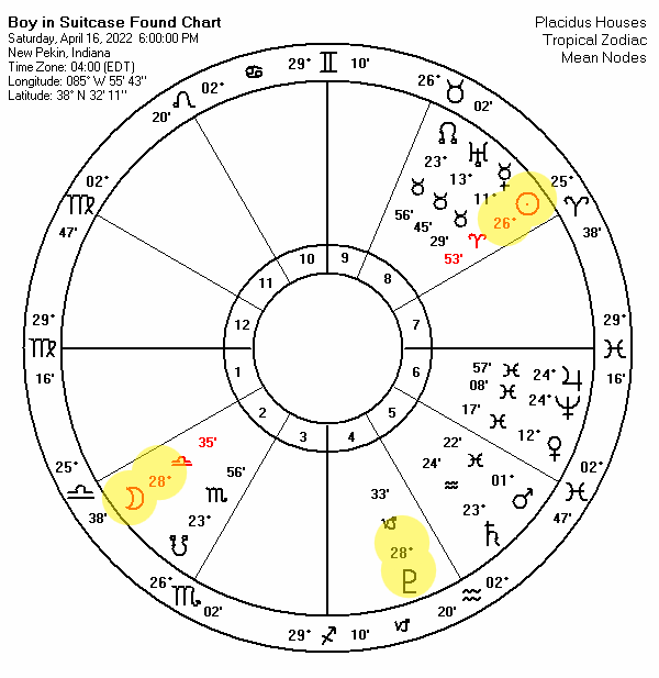 Law Enforcement doesn't know that when the mushroom hunter discovered the boy in suitcase on April 16th, that the Sun in Aries was opposed the Moon in Libra and both were Square to Pluto forming what is know as a TSQUARE. Law Enforcement reported that they believe the boy had only been expired for about a week and that the suitcase didn't look as through it has been there long. They offered it was probably placed there a week before. I went back a week to April 9th and erected a chart for the evening hours. This time the Moon was opposed to Pluto and both in SQUARE to the Sun for a second TSQUARE formation. 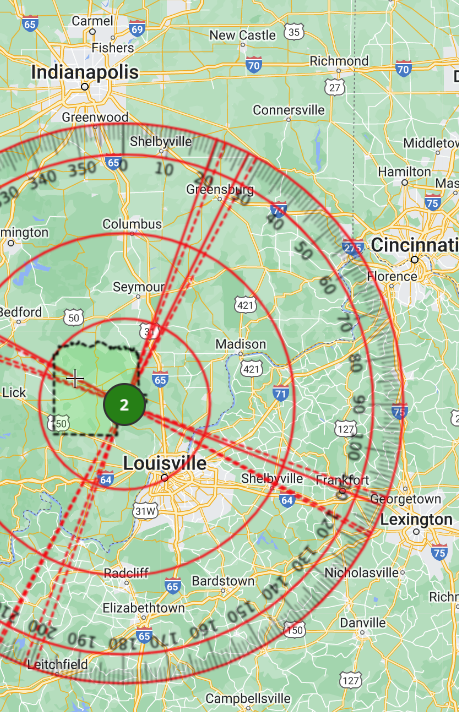 Not only does this TSQUARE aspect lead me to believe that it was probably a women and a man who left the boy there, as the Sun represents a man and the Moon a women; but that this TSQUARE once its measurements are vectored over the point where the boy was found is offering a direction near to Louisville or Lexington, Kentucky. Feels like travels could of taken place from Lexington to Louisville to Indianapolis, or the other way around? Not shown, is a vectored pattern of the Moon Jupiter Neptune Pluto sextile that offers the Indianapolis and Cincinnati area with routes connected to Louisville and Lexington. 'm thinking all HOTELS along and nearby the routes that takes one through these areas need to be checked for a little boy traveling with a women darning that flamboyant suitcase. And a check of the surrounding Good Will type businesses for the sale of this suitcase. Seems like it would be a good start. Using Syntax of the EAST HOLDER ROAD and EAST BETHEL ROAD I am seeking to see if this thought can be confirmed about the people who left that little boy to decay in the woods, just might have been running drugs or sex trades from one place to another, so much so, that they were either very familiar with the area and felt comfortable in the disposal point because they belong somewhere nearby. Of course let me say this, a dead toddler could very well belong to the distant past of one of the folks living there on EAST HOLDER ROAD---but I am going to continue working in the vain that this road is talking to us about this little disposed soul found on April 16th and not to one of the families that live on this road who may have at one time in the past experienced the death of small child. When I anchor the word HOTEL from EAST HOLDER ROAD left over letters offer us DR? ARES DOA HOTEL. Makes me think the child may have died while travelin' and not taken for help (DR) because he died before getting to the HOTEL. HOTEL ROARS DEAD is another re-arrangement of EAST HOLDER ROAD. Perhaps the item of the suitcase has Law Enforcement getting a lead from one of the surrounding HOTELS? In order the solve this case the due diligence in their footwork must turn over a favoring lead. It will be interesting to see how this case gets solved. My word scrying isn't turning up a clue as to who this little one will turn out to be or to who he belongs. I'm anchoring the word LAD with TRASH since its exactly what was done to this little one, and getting, O! ED ROE TRASH LAD. Is it possible that we will learn the person who left the boy in the suitcase in the wood will actually be named, ED? Yes, its quite possible. But in my experience scyring such matters sometimes the names are just indicators of other names. Meaning that ED ROE---could turn out to be a name that also only has two syllables. Could the ED ROE be two people, man and women, ED and ROE? ROE could be short for ROSE or ROSA. HARLOT ROSA DEED is just another descriptive anagram re-arrangement of EAST HOLDER ROAD. EAST HOLDER ROAD is also HR DESOLATE ROAD. The letters HR would stand for Human Remains. When I was working on the syntax the word RESORT kept humming to me and I kept thinking about the suitcase. So I thought I should give it some attention. I anchored it because with the letters left over we could make the word LAD. LAD, HE DO A RESORT. This angram, LAD, HE DO A RESORT, would make me first want to learn if anyone on EAST HOLDER ROAD had any employment past or present the involved one of the areas vacation spots to elminate this finding being connected to the little boy found in those woods. There are some seven houses on this road, and my intrusion scrying into this road that they live on, would certainly tell truths about the other people who live there. I don't know what those truths are---so again, I'm writing, frustrated, that what I might be finding here might not be related to the boy at all. When I look at the stars for when the boy was found, I sight that Merucry is conjunct Uranus. This could indicate a child that is mentally or physically challenged. I also found the words RETARD and RETARDED living in text string EAST HOLDER ROAD for the anagram OH! ALSO RETARDED. It was read in an article that the boy was found around 7:30 PM, if this is true, then Uranus is ruling the 5th house of children describing the boy with a mental or physical deficiency. Venus is 12 degrees of Pisces in a sextile to the MercuryUranus conjunction, telling me the mother loved this child, but Mars, the Male or Dad, also in Pisces. is in a further away conjunction to Venus, ----which sort of leads me to believe the Dad's love for this boy was not so much. It was probably his idea to leave the boy in these woods. Know that it does trouble this writer to score about these two roads, East Holder and East Bethel. I know wonderful and caring people deducated to their children reside on these roads and here I am calling out all these troublesome vibrations emitting from the place where they live. Do I even have a right to intrude? Some may think not. I do however think there maybe something of some value to whats written here that could be correct and hopefully helpful---else I wouldn't of felt the pull to dig into an analysis. EAST BETHEL ROAD uncannily anagrams into ETA HOLDER BEAST. Perhaps a lead on this beast and his vehicle transporting our little one in a suitcase will reveal the Estimated Time of Arrival for when they made their turn onto East Holder Road. Ring Doorbell, a witness perhaps, an unfamiliar cell ping? E! ED HARLOT. BEAST or is it DEE HARLOT BEAST. Would it be unreasonable to think something nafarious was happening in one of the homes on EAST BETHEL ROAD? While EAST HOLDER ROAD was just a short drive away for a dumping? I'm wondering. I'm sorry, but I do not like the fact that the same words DEATH, HOTELS and HARLOTS are also being found hiding inside EAST BETHEL ROAD. But also hiding BRATS and BROTHELS. EAST BETHEL ROAD is E! LEO'S BRAT DEATH. The Sun moves into the sign of LEO on July 23rd and transits through until August 22nd. Could we learn more about this case and an arrest sometime during that period of time? Or, could the precision of the anagram be telling us that our little unknown boy was born under the Leo Sun Sign? I'm very eager to find out and I'm am very troubled by what I also found hiding inside the names of these roads that I didn't have the heart to write down. 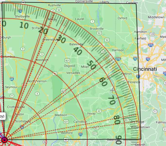 I've been mulling over the dastardly details on the remains recovery of murdered children for over thirty years. I don't only consult the stars for clues to their whereabouts and the happenings that got them there, but I always scry their names as well. I've learned their names can be trusted for the truth. Do I get it right all the time? No, of course not. But I am quite surprised and confident in what I found and shared thus far with readers, but I want to go one step further. I want to look at the text string BOY IN THE VEGAS SUITCASE. When this little one was found on April 16th, it was a Saturday. SAT SIC BOY IS A HUGE EVENT is a truthful re-arrangement of BOY IN THE VEGAS SUITCASE. The community was astonished and they very heart-warmingly saw to it that this little one got a proper goodbye and burial. Maybe also, the anagram, YES! GOTCHA! A ENE BUS VISIT is suggesting the boy did travel to the area by bus. And its offering the direction East by North East, which can otherwise be written as ENE. I highlighted the North East Quadrant of the map that AMAP has constructed. Showing vectors for three different planetary patterns that were present when this little one was left in those woods and where they are pulling throughout the whole North East Quadrant. These vectors represent the
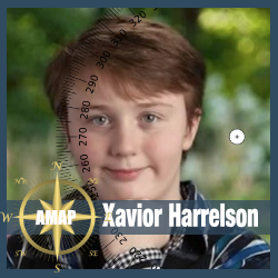
I only went out 50 miles with my compass, but you can easily see that the city of Cincinnati and the surrounding area could hold some promise as to from where this little one might have traveled. I found this most interesting because if he did travel from this East by North East direction they would of had to cross the Ohio River. This is interesting find because I reached out to one of my associates and ask her if she could throw a few cards over on the topic of this boy in the suitcase. Below is the reading she sent back to me. The 10 of Clubs showed up over the Ace of Hearts in the reading it means a family may have moved over a body of water. Perhaps its was the Ohio River. I'm keeping my fingers crossed Law Enforcement is going to wrap this up come August 2022. In the meantime, prayers and acolades to the people of Indiana who gave this little one a proper good-bye. God is Good. Cartomancy Consult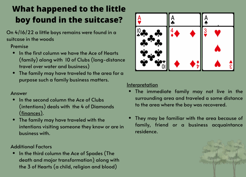  Xavior HarrelsonDate of Birth: May 30, 2010 Point of Disappearance / Circumstances
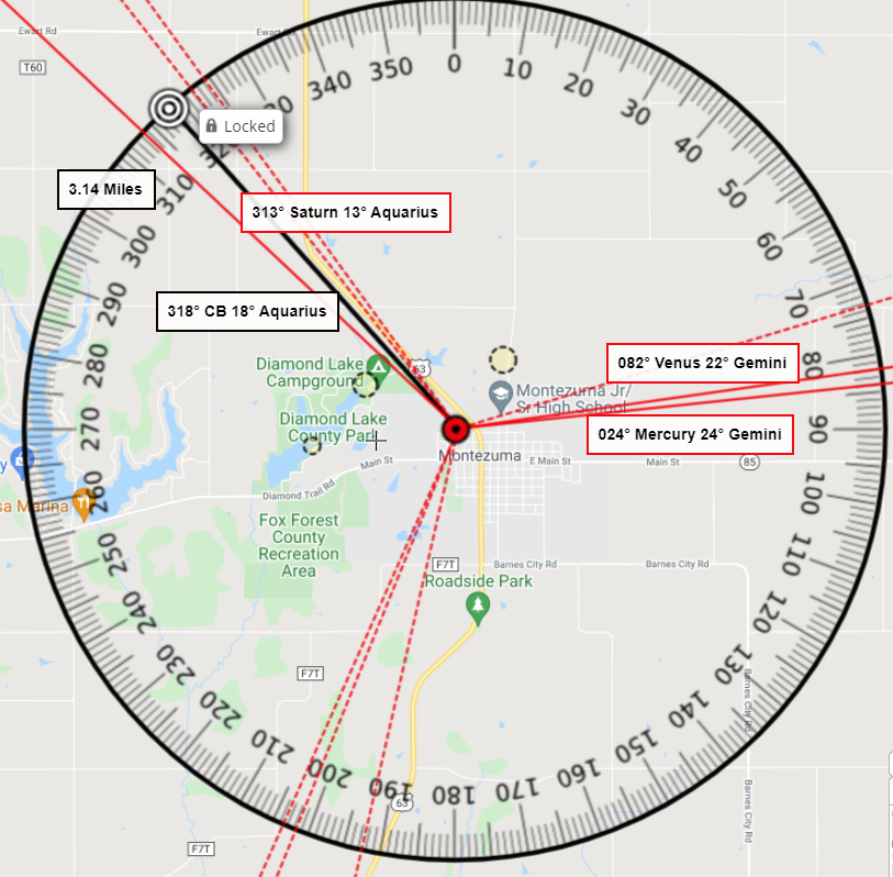
AMAP comments on Xavior's case The interactive map we produced on Xavior's case was shared with a few searchers who were looking for Xavior, sadly we did not have any hotspots directly near to his location. We did have two hotspots north of Ewart Road over the North English River figuring the Mars in Cancer opposition to Pluto in Capricorn would of had him close to a water source. But even those mapped Hot Spots were some two miles NE away from where Xavior was found. My attention was focusing on the areas offered by the Moon Mercruy Venus Oppostion in TSquare to Neptune that we vectored on to the compass in his map. I made the mistake of not using Saturn as the solidfying force that he has been proving to be in the cases of children who are found. I missed it. Time got away from me and I didn't get Aprils' pair of eyes to double check my work on Xaviors' map. Oh, the irony! You see, Xavior was found five ticks away from Saturn's vectored measument at 13° Aquarius. Xaviors' found bearing from his point of disappearance was measured as 318° or 18° Aquarius. This faultly sighting of mine not to HOT SPOT an area that has a SATURN involvement is very annoying to me because in the 159 cases of child recoveries we've collected to date we've noted that SATURN 72% of the time is forming an aspect to the found bearing. April and I have discussed this sighting at length. And we are very nearly leaning towards owning the idea that we could probably use Saturns position at disappearance to help us develop our Hotspots. I did vector out a pattern for the Sun Saturn Trine aspect, but never hotspotted anything over it. As for distance, no measured planet in the disappearance chart offered the 3.14 direct miles he was found. He did however, have Pluto at birth 4 degrees of Capricorn which would of offered near distance by a 1° orb. The image below reflects the Sun Saturn Trine that I didn't hotspot. 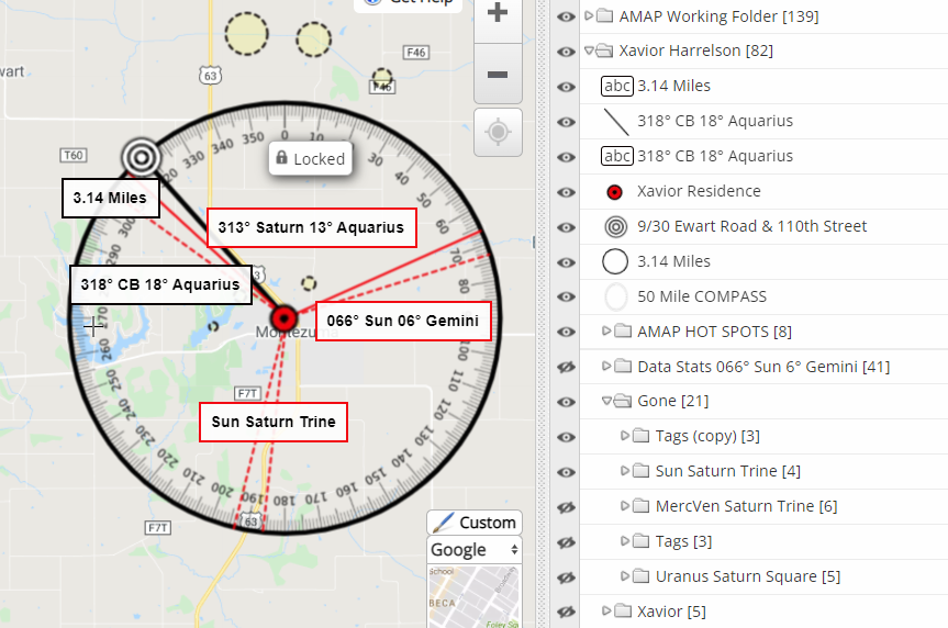 We could of used this Sun Saturn Trine aspect as the pattern Xavior was found on, but the bulleyes for his location falls inbetween the vectors offered by the Mercury Venus conjunction in Trine to Saturn. This fall-inbetween-the-vectors sighting of the bulleyes is something that happens more often than it doesn't. It's best we use it as the reminder to that fact. On another note. Xaviors' case is still under investigation. We do not know as of this writing who left his remains on 110th Street just South of Ewart. However, if the the Sun on the day of his disappearance has anything to say about it, its seems the chances are high that Xaviors knows the person that left him there. Below is a screen shot taken from our data sheet on the 10 other children cases we looked at for when the Sun was in the sign of Gemini at the time of disappearance. We had a total of 14 cases, for which 4 were unsolved--- so hopefully that commincating nature of a Gemini Sun will soon tell us who did this Xavior. We should see a solved case. 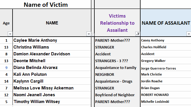 In closing,
Adding Xavior Harrelson to our case study makes 159 cases of children in our study to date. Although his case data is being added to our study making room for his case and others is becoming a nightmare to get loaded on our study pages for public viewing. So any new case studies will be added to our data and illustrated either in a page post or by blog post. Please keep in mind that although AMAP is not frequently active on our social media platforms doesn't mean we aren't keeping up with current cases. If we think we can help, we send our maps into Law Enforcement. And, we are working hard in the background seeing what we can learn from the 159 case data for the children which we were able to acquire birth charts. We are busy with both our professional and personal lives while using the time inbetween for everything AMAP so we get better at hot spotting directions and distances because the data we collected is synthasizing a sort of intelligent instinct. Yet still, the magnitude of this case study undertaking has been pain-staking, yet worth every ounce of effort and of course that includes admitting our mistakes, such as it was with little Xavior Harrelson. He derserved better than that from us at this point in our work. I should of never missed it. I'll leave my ramblings there, and offer you some Highlights from our findings to date ...
Updated 2/3/2021 BASED ON NEW INFORMATION
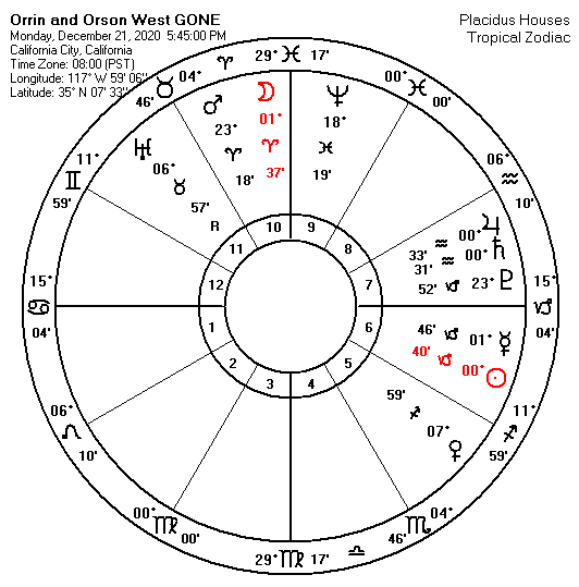
 Interactive Map in the matter of ORRIN AND ORSON WEST
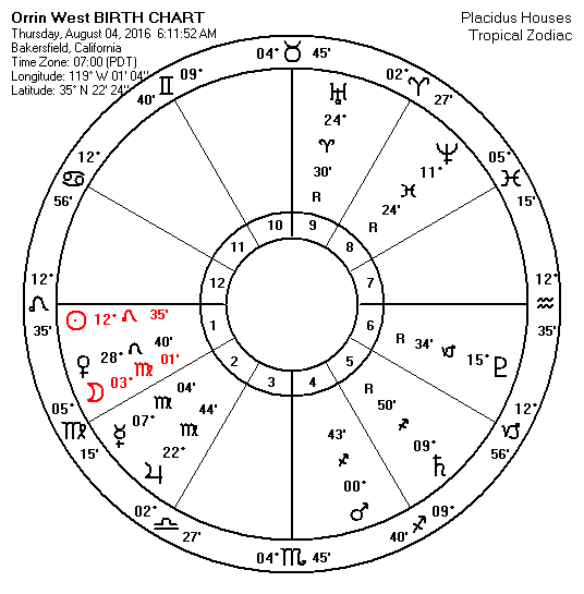
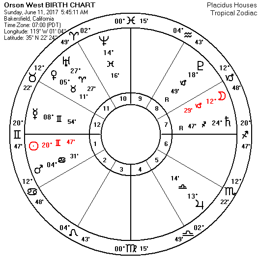
Birth Chart Analysis
Both boys Sun and Moons are afflicted at birth at the time of their disappearance suggesting a strong possibility the search should be a remains recovery.
SYNTAX Analysis on their Names The hotspots in AMAP's Interactive Map reflect areas near the railroad. Our attention was taken there because the letters comprising the boys names, ORRIN AND ORSON WEST, when rearranged can be syntaxed to suggest TWO SONS, ONE RR DRAIN. These boys are missing together, TWO SONS are missing; and the name phrase is suggesting to us that they are both near DRAINS by the Rail Road. Uranus rules the railroad and its affecting natal planets for both of the boys at the time of this disappearance which could help suggest an area near not only the Rail lines, but electrical towers such as cell towers and/or power line pythons. Also, why would their name together when its words are rearranged syntax to tell us, NOW, RR NOON DISASTER? What happened in the home at around NOON the day of disappearance, or the day before? N WOOD IS TREASON, N RR is another disturbing find of the names phrase ORRIS AND ORSON WEST. Didn't their adoptive father relay they boys disappeared while he was looking for WOOD? Couldn't a child consider that to be Treason if it is a lie to help sell the story that the boys just slip out of the backyard? When the boys may already had been placed somewhere near the railway? UPDATED to reflect correct spelling 3/9/2021 The sounds we speak are powerful. Science is now using sound to heal illnesses. Our names, when spoken, written and even thought of are emit sound frequencies into the ethers and they manifest. I even took a peek at the name phrase, TREZELL AND JAQUELINE WEST to see if it could tell us anything of value. Earlier I mentioned that their could of been a problem with potty training, this was due to knowing the ages of the boys and considering the Virgo and Gemini connotations of the Moon in Virgos ones chart, and the Sun in Gemini in the others. I found the word QUARANTINE! I'm sure there are lots of parents who are nearing the end of their ropes being cooped up home with small children, who might not be progressing well in the area of potty training. I'm not making excuses for them, but just trying to see what their names together can tell us.
This Venus Neptune planetary aspect is considered to be a WIDE SQUARE being that they are 11° degrees apart from being an exact 90°; as Venus is 7° mutable Sag and Neptune is 18° mutable Pisces; yet they are still considered to be Square by mutable sign signature. See 2/3/2021 Update Below But the really cool part is that I am the one TELLing this TALE and I hale from NJ but right now I resdie in Ohio, and have to be in a place of ZEN to repeatedly do this work that involves the tragedies of children. The only reason I took a look at this case is because it involves children and it was brought to my attention by several of our followers asking if we could help in the search efforts. So I'm hoping the auspicious coincidence of my own sightings of having something about me living inside the names of the two people who are connected to two boys missing means I might just have something of value to offer the community there in California City looking for Orrin and Orson West. 2/3/2021 Update: Information received for a date of birth for step parent Trezell West as 9/24/86. If this date of birth is in fact correct, this date of birth triggers two aspects occurring at the time of disappearance that have been vectored in our map for potent directions for the West Boys. They are, one, the wide Venus Neptune Square as already mentioned; and two, the SunMercury Moon Square. This new information led me to update the West Boys' map to reflect a hotspot North of the home near the rail road. (please see map) I would like to add here that due to the fact that this birth chart reflects a NeptunePluto sextile that was being triggered by both the Sun and Jupiter and Saturn at the time of disappearance, we may want to pay attention to large pipes in the dirt type of drainage or even wells in the ground for a recovery. Not sure I don't see a confession coming soon. Moon in Gemini with an Uranus opposition suggests events in the home being exposed. Dates of promise could be February 15th or 23th.
It was about 6:30 PM near Megan's own residence on Barbara Lee Lane in Hamilton, New Jersey when Timmendequas lured Megan into his neighboring home. She was found the next day murdered, raped and strangled after Timmendequas confessed to Law Enforcement for being responsible for her disappearance. Megan's remains were recovered 2.9 direct miles away from her home at a compass bearing of 36° which can otherwise be expressed as 06° Taurus in the weeded area on the West Windsor side of Mercer County Park. The Moon was 00° Taurus, just 6° away from this point. We consider her to be found on a Conjunction to MOON which was involved in a TSQUARE with the Sun and Jupiter that was in present transit at time of her disappearance on July 29, 1994 at 6:30 PM. In the photo slide show below you can move yourself through the charts and maps to view the chart to map illustrations of this aspect against the terrain and see how those measurements vectored from the location of her disappearance (red target), aligned into the area of Mercer County Park where she was recovered (bulls eye). Also included in this interactive slide show are the Birth Charts and Maps for both Megan and Timmendequas.
When Megan was born on December 7, 1986, her Venus and Pluto were conjunct in the sign of Scorpio, at the 7th and 8th degree. This position is in direct opposition to the 6° of Taurus / 36° to the measurement of the compass bearing to where she was found. Megan's own stars at birth matched up to this major angle and foretold of her recovery location. While Timmendequas' birth chart, saw his own natal Fix TSquare involving the Moon Jupiter and Neptune offer the finishing point to this location. The Data on Children Killed by their NeighborsHere is how we are hoping to learn more about these types of crimes by aggregating the data and continuing to add more cases as we learn of them and their case particulars. I personally would like to have a wider exposure to more like cases, however as far as we gotten to this point, here is what we've seen in cases of neighbors as the predator in regards to point of disappearance POR to point of recovery POR. Of the 348 cases of both Children and Adults in our study as of this date. We've studied 10 cases of children who were killed by their neighbors, like Megan Kanka; but that is from the cases that have been solved by a conviction. There could be more cases in our study that were also killed by neighbors, we just know which of them they are, because they cases sadly remain unsolved. Of those 10 cases
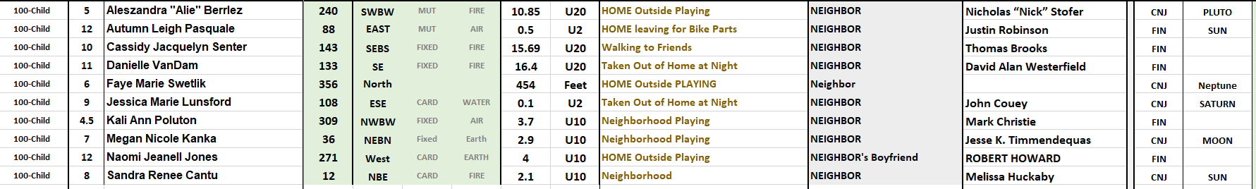 OUR MISSONLittle Megan Kanka's case is another beacon of hope to us here at AMAP. I will not share her picture here on the same page as Jesse Timmendequas. But her face is ingrained into my heart. Along with the introduction of the Megan's Law implement after her murder, which required Law Enforcement to make available to the public the location of registered sex offenders; We too are using her case as an instrument in the terms of location, only we want to help find these children after they are been grossly disposed of by these predators who mostly don't confess, but leave us searching in torment for our missing children. We are using Megan's case among the other children in our case study to show how our missing are being found in the geometry of the planetary aspects occurring at the time of their disappearance. We are educating the public about this study. We won't give up to world knows we just might have help finding our missing children and love one's in the stars. Rest in Peace, Sweetheart. You are not forgotten. 
Sweet little Diana was taken out of own Fort Myers home in the middle of the night on May 29, 2016 by Jorge Guerrero-Torres. Torres, at a point prior to Diana's abduction, lived in the home with Diana's family. Torres has been in jail serving a 40 year sentence for child pornography.
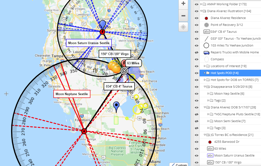
The Syntax of DIANA BELINDA ALVAREZ
Today after learning of Law Enforcement's ID of little Diane Alvarez a little peace hovers over my heart. I also find solace in knowing that those words living in Diana's name were correct in telling me about the location of where she would be found would be near Oranges.
The hearts of Diana's family, friends and those searchers and LE folks who worked hard to find her finally have an answer to a agonizing question. Diana now gets to have a proper Good-bye. So its a good day. We will be adding Diana case to our study and will illustrate the findings below. ---and now we wait, we still wait for
Case Study: dIANA aLVAREZ
Date of Birth: May 17, 2007
Data Sources
When you understand that the Sun ticks like a clock one to two degrees a day, this information becomes eye opening in that the natal Sun of missing victim can be trusted to offer potent areas for search efforts as offered by the vectors draw to account for these aspects. When these vectors are combined and synthesized with the knowledge of the surrounding terrain and the unfolding of learned details of a disappearance such as cell pings and other locations of interest, the position of the Sun becomes instrumental in hot spotting locations for recovery.
This study is in an effort to solve the problem of whereabouts and to narrow down the 360 degrees of probable directions to search for the missing. We are looking at all the planets measurements at disappearance and at birth the same way we took a look at the Sun. We are seeing like numbers showing up for the Sun again at the time of disappearance as well. So the Sun, this monumental mass of heat and energy, as a binary star that holds in its grip all the planets to a measurable rhythm, seems to maintaining his station out there. While his influence here on the ground, as AMAP sees it, is searing a path for us follow. A path cast by a ray of light that could offer us assistance to find the missing. Whats important to remember is that our work is not intended to replace sound investigative procedure but to work alongside it as standard arsenal when searching for the missing. Sacred geometry underpins all matter on Earth. When forced to summarize the general theory of relatively in one sentence, Albert Einstein said, "Time and space and gravitation have no separate existence from matter."
"The only thing necessary for the triumph of evil is for good men to do nothing." ~burke
Update November 25, 2019Law Enforcement believe they have recovered the remains of Aniah Blanchard today near the 38000 block of County Road 2 in Shorter, Alabama. Link to Article Point of Recovery measure 244° / 4° Sagittarius from the Chevron in Auburn at a direct distance of 31 miles. As expected she was found inside the data wheel for the shaded area that reflects a Square (90° angle) to the Moon's 5° Virgo at the time of disappearance. Which triggered her own Moon Pluto Square at birth. She was found in between the vectors the measured from her birth chart erected for Sunrise with Pluto at 11° Sagittarius and the Moon's 01° Pisces. Rest in Peace, Aniah. 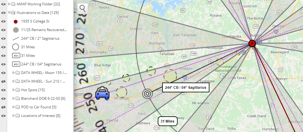
The chart below reflects the number of times across the 60 cases of how often the Sun and Moon made major and minor geometric angles to the found bearing.
The yellow circles in the map are AMAP's hot spots from experience sightings in other such cases. These hotspots are aligning with planetary patterns that are typically illustrated in our maps---but for the sake of time to get this map out to the public for their search efforts--we are using the Data Wheel to shortcut our procedure--which is always based in results of looking at 60 similar type cases. These hotspots reflect the following roads to consider for a search effort. Best to see these areas using the Interactive Map constructed on her behalf.
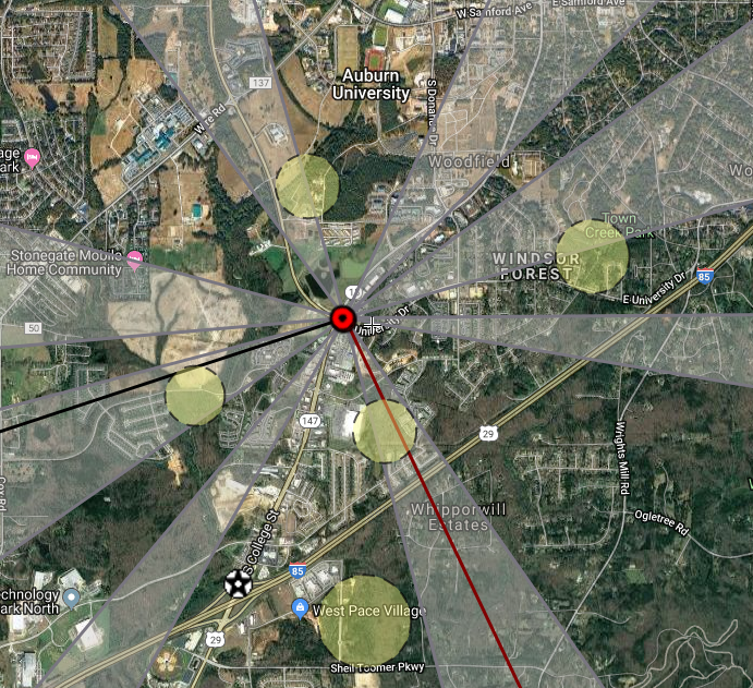 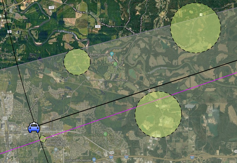 In our Study of 60 Adults there are
Coincidentally, it was read in a recent article that Aniah's mother would like to have the Ashanti Alert Act issued which President Trump signed into law last year creating a nationwide alert system for missing, endangered adults between the ages of 18 and 64. It's uncanny that she brings up the case of Ashanti Billie, since the details of Ashanti's case is one in which we are seeing a similar pattern that could help us with Aniah's case. It's seems to be a clear push from the universe that we should pay attention to this Moon Pluto Square aspect that was formed on Aniah's date of birth and the areas it aligns overs as well as AMAP's data wheel. Two Similar Cases Examples
Disappearance Measurements from POD to POR
Birth Chart Measurements from POD to POR
Disappearance Measurements from POD to POR
Birth Chart Measurements from Spurlock's Residence to Spark's apartment
Lastly, It's important that our maps are used alongside the knowledge of area and the details that are coming to light in the investigation in terms of cell activity and the activity of known persons of interest. Sadly, It must be considered that Aniah has met with foul play. Which means that search efforts are swaying towards a remains recovery. But keep in mind our map can serve to be used for search efforts that involved a captive scenario. If Aniah is being held against her will consider our effort to work on her case being done because we believe she can be found. We are here answer any questions about this work that will help serve the search efforts taking place.  The exact location inside the Tom Brown Villa Apartment complex located on 5th Ct N in Birmingham, Alabama where three year-old Kamille McKinney was last seen on Saturday, October 12th at 8:30 AM is not known to us at AMAP. But that doesn't stop us from measuring distance and direction from that general location to the trash bin located at the Landfill where Kamille's remains were recovered by Law Enforcement on October 22nd. We are interested in adding Kamille's case particulars to our study. If you are not familiar with the work we do at a Matter of Perception (aka: AMAP) here is a brief explanation of our interest in abducted/missing children. We have been conducting our own study measuring the direct distance and compass bearing from point of disappearance to point of recovery in missing children cases in an effort to see if a predictable system of identity exists to help laser focus search efforts in new cases. There is no time to look in the wrong direction for a missing child. Time is of the essence. Sadly, AMAP wasn't available to erect an interactive map for whereabouts on her behalf, but the details of her case are still important to us. We will take a look at details of Kamille McKinney's case against the astronomical process in this writing. The distance and direction from point of disappearance to point of recovery can be calculated to measure as being roughly 13 direct miles as the crow flies from the Tom Brown Villas tot he Landfill; and to be at a bearing (or heading) of 344° on the compass--which can otherwise be expressed on 14° of Pisces. Both of these numeric digits have a parallel with the astronomical process. The planet Neptune measured 16° of Pisces in square to Jupiter at 19° of Sagittarius. AMAP considers her recovery to fall under the govern of the Jupiter Neptune Square that was happening at the time of her abduction. While no planet exactly measured 13 degrees of its sign signature to give distance---both Mercury and Saturn in their respective degrees of 12 and 14 in the Scorpio and Capricorn sign signatures did offer near distance. 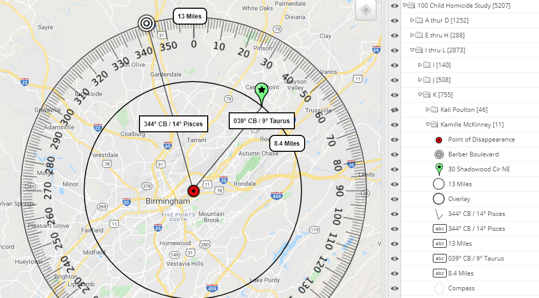 In the image above, the red target is the point of Kamille's abduction, while the white bulls-eye is the point of her remains recovery. The Green paddle is address connected to the two people involved in her disappearance. The two black lines are the vectored measurements to those two locations.
Highlighted in blue, we have the Venus Uranus opposition (illustrated below) that was in effect at the time of her abduction. This planetary pattern pulls out to the location ---30 Shadowood Circle NE---where Law Enforcement recovered the vehicle caught on surveillance footage that is believed to have been used in the heinous nerve rattling abduction of Kamille while she was playing with other children enjoying the gathering of a birthday party. If we were to vector their measurements onto the compass they would head out to the location where the abductors vehicle was confiscated by Law Enforcement.
Once Law Enforcement was aware of the two responsible for this abduction they were able to concentrate on trash bins coming out of the Central Point area to bring about a recovery. The case is still being investigated. God Bless Law Enforcement. It was a bittersweet find when you understand many children are still missing following similar circumstances. We extend our prayers to her family and the people who tirelessly worked to bring her home. We will honor Kamille's life by making sure her case teaches us something towards our goals. To us she is a Beacon of Light. You could view AMAP's 100 Child Homicide Study measuring point of disappearance to point of recovery at the link provided above. We have provided Map illustrations revealing the planetary patterns that offered directions to the recovery of over one hundred cases that span the years from 1932 to the present. Each of them echo that our missing are being found in the geometry. Support Our Efforts with a Purchase of Your Own Natal Birth Chart Your support helps us to keep this study public and our interactive maps available on a 24/7 platform
for those who are still missing. UPDATE: Remains Recovered 9/3/2019 at Pine Ridge Park, Blairsville, PA 091° Compass Bearing @ distance of 31 direct Miles
That natal Moon has a troubin' direction to Square natal Uranus---a combination that could indicate a sudden incident and danger to Nalani's health such as being missing under such circumstances.
Since Law Enforcement has been forthcoming with information in regards to both a timeline of events and areas of interest that have unfolded thus far---AMAP has erected an interactive map on Nalani's behalf to show directions and distances that will show potent directions and distances that could hold promise for Nalani's whereabouts. Below is a screen shot of several areas South East from the point of disappearance that we think deserve focus for a search efforts.  While Nalani's own birth stars speaks of a an unstable women, this womens' own name, SHARENA ISLAM NANCY, seems to offer -- N MY CAR HAS NALANI SE. Yes, troublin' to say the least--- that Nalani's name and the word CAR anchored leaves enough letters left over to suggest an area that is SE--but to inlcude also the words, N MY HAS. Don't you think? News confirms areas of interest that are in fact South East of where Nalani was last seen. Also disturbingly found hidden in name of the women last to see Nalani, SHARENA ISLAM NANCY are the words ... REMAINS, SLAY, HARM, MARS, MILES, SEARCH, CANALS,
CANS could possibly stand for the metal cylinders under roads for water drainage, but it could very well mean trash cans too---so the public should check the trash bins on both commercial and private properties---she is too little for a trash disposal not to be considered.
A NANNY CAR HAS MILES --- I think drivers put lots of miles on their vehicles. So this is a fitting anagram for this persons' life---but I need to anchor another word that is troubling to this word MILES---one that could make sense to this situation. So in keeping the word MILES anchored,I saw the troubling word CAN could still be made ... RAN MILES, HAS ANY CAN. This sadly sends the message to me that, "Yes! this person working as a driver for a living would have lots of background knowledge for a successful disposal---and lots of associates made. So this is scary, because her name also reveals, NALANI, MANY SEARCH(S) MERCY is another word I found in her name, and I am hoping that ALAS! HAS NAN IN MERCY is an indication police might get this Nancy lady talking. Let's hope so. One thing that keeps standing out to me, and that's the strength of the Sun and Mars here at this disappearance ---and the Moons' completed trine to Pluto at this event. Sort of giving me the idea that Womens' work was done---and there was still yet male energy culminating. Could she of passed Nalani off to someone? I'm a bit hard pressed thinking that there is not any male involvement here. I'd like to know with what males this one associates? Updates 9/2/2019 in Progress
Links to News Articles for Missing Nalani Johnson
Astrological profile at DisappearanceIt's understand that a search today, 6/26, is happening at the landfill. Please note that the Mars Opposition apsect pattern does pull out to the landfil, and would certainly offer this direction some potency. If however, nothing is found at this location, please direct focus towards the planetary patterns offered by the Moon and the Sun at his disappearance.
The Moon Neptune TSquare at the time of Noahs' disappearance is being highlighted in the above illustration, with hot spots heading both into the North by West areas and the South by East areas both of which we suggest could prove fruitful for search efforts. There is also an area West along the James TW Pier that is also of interest. I know that there is suppose to be a command center being led from there, but my question is, 'was the pier accessible during the evening hours just prior to 1:00 AM or after? Has there been divers in this area of the water?  Astrological profile at Birth for May 2, 2017
Hard not to imagine a male having some part in this strange disappearance with the elements of having a MarsNeptune Square and a Sun Pluto Trine. I would think both suggest some foul play and not so much little Noah getting lost all on his own. If the Moon is in Leo, its early and trines Venus---could suggest Mom has some problems with Money; and while his Mars in Gemini trines up to Jupiter while it Squares Neptune this doe very little to suggest a stranger as much of someone known to his mother or family member. Who does the mother and/or her family interact with---I would start there. Is there any money owed?
Update 5/31: The remains of a child have been recovered from a ditch in a trash bag off of Exit 18 along Interstate 30 in Fulton, Arkansas. The trash bag was noticed by road maintenance workers mowing the area of the exit days ago and brought it to the attention of superiors who disregarded the find until Law Enforcement from Houston were led to the Interstate near Hope, Arkansas by a confession from the mother's boyfriend, Derion Vence. Link to news report.
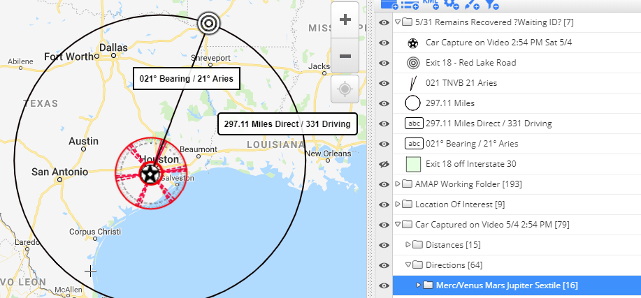
This writing in for those in Sugar Land, Texas in the trenches and looking for Maleah. In in this writing where I will be exploring what his name might be telling us as to where we might set our sites on recovering Maleah Davis. I hope it will serve to be used in alongside our Interactive Map.
If you take the time to visit Maleah pages at our site, you'll note that prior to the family vehicle being found I clearly bring up the idea of the vehicle being located somewhere in an alley or mall type environment. This is something that MALEAH LYNN DAVIS' name was hinting to me, its why I wrote it down. Her name told me YES! HID A VAN N MALL.
Her name hides within it the words, HIDES, VANISHED, DIES and VANDALISM. But I stuck with constraining the word HID because I was hoping it would tell me something else about where he might of hidden her---and I got, HID ME SLAY with the letters N NAVAL left over--so is she by something that has to do with the NAVY or military in anyway? recruitment centers, training centers, land that may belong to the NAVY or military---please consider this while searching. But, lets also consider that those letters could refer to something else---this is my struggle with this process. Could it be HID ME SLAY VAN LAN---that sounds like some sort of car lot for sales--do any of them in your area sit by the river or bayou and is also near a wooded or high grass area? Think. Below is a screen capture of part of our interactive map showing some of the southern areas from Maleah's Sugar Land home as her point of disappearance (not GreenRoad). The yellow highlights are my hot spots because Maleah's own stars at her birth are pointing us into these directions. 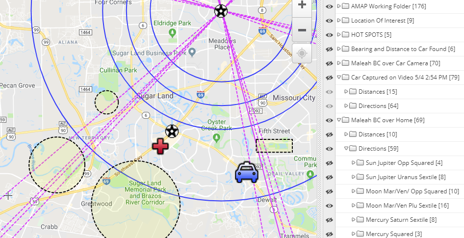
The pink lines in this map are a part of Maleahs' own star pattern offered by the Moon's placement at her birth and its relationship with the planets Mars Venus and Pluto. This aspect was being triggered by a transiting planet at the time of disappearance and its one of her patterns we feel she could be recovered on---the family vehicle was already recovered on this pattern, as you can see in the map.
Thus far our map is working, please use it in your search efforts.
Mars in Transit is opposed to Jupiter and both are squaring Maleahs' own natal Mars which is sort of giving us the impression of a road that would be used for long distance travel---so keeps roads in mind that have direct off access by way of exits off the major highways and thoroughfares.
At this point in time, Maleahs' name is not offering to me an idea of the type of environment for her remains recovery. Meaning on land or in water. As much as I want it too, the only thing I can get is M SLAIN HEAVY LAND --The M of course stands for Maleah but I have no idea what the word HEAVY could mean. The only thing I can think of to translate this word HEAVY is that it is important some how, perhaps owned by someone or some company that is important to the area or perhaps this land is over populated with something. Perhaps Trash, Woods, or Junk.
There are other hotspots in our map that are near to roads 99 and 90 ... the wooded area off these roads are too of interest to us and should be searched.
There are more disturbing words that can be born of the name DERION MARQUISE VENCE such as EVIDENCE - DIVORCE - RIVERSIDE - CONNIVER - DIVIANCE and SEDUCIVE
So its here where I am hoping that the name DERION MARQUISE VENCE will give us what we need to find Maleah.
Remember, at the start of this writing I told you his name hid the words REMAINS and MURDER CASE within its frame. But before I begin scrying his name below for the truth about Maleahs' whereabouts Below is Maleah's natal birth chart. Let's explore it for more clues.
---its important that I mention here that Maleahs' stars at birth, her Venus and Mars in Pisces was being triggered by a transit from Neptune--so its a strong possibility that she is in or very near to the water. I highlighted in yellow the stars in her chart that were being activated by transiting planets at her disappearance---from our experience measuring point of disappearance to point of recovery we have learned its extremely important to pay attention to planetary triggers in Transit.
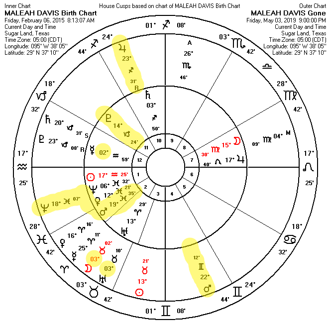
The Name DERION MARQUISE VENCE
EQ could perhaps serve to speak of Texas EquuSearch. I understand they are part of the search efforts for Maleah. Well, Texas EquuSearch if the QU in his name has anything to do with you---it appears his name is telling me one of the folks associated with TES could be responsible for discovering her remains as his name is telling us EQU REND REMAINS with the letters I COVE ---- don't forget I mentioned this word COVE earlier a few paragraphs back.
I am not writing this to send searchers on a wild goose chase. I'm trying to illustrate that how we sound is how we manifest our lives---there are other articles here in our blog and at our site that reveal how a victims name help to tell us where their remains were located. It's not going to be any different with him---or Maleah Davis---neither of them is above the universal laws of attraction. And the attraction is that when our names are spoken they emit omnipotent sound frequencies that take shape upon the ether.
It is why affirmations and prayers are so powerful. And it certainly explains why we are now learning that this man named DERION MARQUISE VENCE has been spoken ----and its omnipotent sound frequencies have taken shape upon the ether, into, EQU IRON MARS EVIDENCE. The planet Mars will always be the planet associated with war and violence, and so it rules over this MURDER CASE just as his name tells it will. The word MARS sits along side the words EVIDENCE and IRON and EQU. Its' clear we need EVIDENCE to convict DMV for this crime against Maleah, and its EERIE that EQU happens to be on the scene there in Texas to help with the search efforts and in his name. EQU, IRON MARS EVIDENCE ... his name is talking distinctly with Texas EquuSearch in mind. I am hoping that it is foretelling that they are going to find her with or without the help of our map. But if you are in Texas and you are searching for Maleah and have a member of Texas EquuSearch near---please, please show them this writing. And refresh your browswer as it is a work in real time progress.
I think the above anagram of his name is telling TES to find a private accessible COVE sort of area off one of the ROADS with a NINE (9) in its name to search for Maleah.
Lastly, before you disregard this play on their names to offer us the truth, know that his own name is telling us, R UNIVERSE CODE NAME IQ. And the word phrase PEOPLES NAMES can anagram into ONES SLEEP MAP and MAP POSE LENSE. 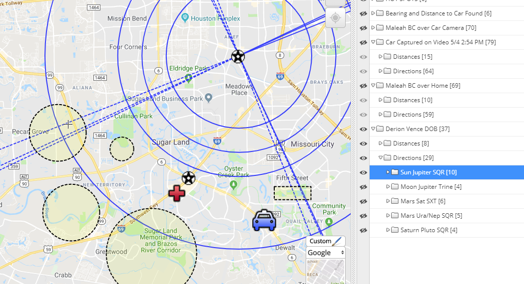
In the map image above, I have turned on Derion's Sun Jupiter Square Pattern vectors over his home. This could very well be the pattern he used to innately decide where he would dispose of Maleah--
Please give areas in and around these lines and our hot spots interest in your search efforts. His name is giving me what I hoped it would, a planetary pattern to pay attention too. His name DERION MARQUISE VENCE is offering EQ! MINE SUN CODE A RIVER. However, his Mars Uranus Neptune Square pattern is also troublin' and it too should be considered. Our hot spots cover these patterns and can be better explored through interaction with our map when viewed on a desktop or tablet. Be safe. God Speed. Please leave you questions below in the comments and please forgive any spelling or grammar errors in this writing---it was done in speed with the intention it would service to help find little Maleah Davis. Come on Maleah, give searchers the sign they need to find you, Sweetheart.
Update 7/11: Remains have been Recovered
 Savannah's Residence to David Sparks's Residence. Her natal Pluto falls just a few blocks from David Sparks's residence. Previous Publishing
Law Enforcement needs something tangible to help them find her. It's seems there is no confession and all searches thus far haven't returned Savannah back to the people of Kentucky. Although we don't know everything Law Enforcement knows; It's not stopping the souls in Kentucky from being mysteriously aflamed to search for Savannah. Most of the folks I've been conversing with don't understand themselves why they are being raddled by this strange disappearance of a female they don't personally know.
So I too am emotionally fevered here in Ohio on her vanishing, because searchers on foot there in Kentucky are looking for Savanna in creeks, marshes and woods; and most of them aren't equipped or experienced to find Savannah in the Water. It's got to be one of the most murkiest and hardest jobs for the divers in Law Enforcement to search for remains in water. But, I think the name of SAVANNAH MARIE SPURLOCK herself ----is telling us we need to USE SONAR, into some of the deeper waters in the area. As a matter of fact, her name is telling us to, AHA! USE SONAR, LINK RV CAMP. Wait a minute---Lancaster, the town where it's believed she was last seen alive, is just south of CAMP NELSON. Using these two words as an ANCHOR, which by the way is another word that can be born of her name, we are getting the anagram word phrase, AHA! A NELSON RV CAMP IRK US. It's my understanding that searchers have their sights on the area surrounding CAMP NELSON. Isn't it startling to learn that her own name is actually describing the people who are there in Kentucky searching for her? I do. Is she there? Is Savannah in the area of CAMP NELSON? Hard to tell when the area is so heavily supplied with two Rivers, the Dix and the Kentucky---and then note all the little creeks and canals that fork off the two. My peek at a map of the area shows that the CAMP NELSON area sits in between the Kentucky River and Hickman Creek. Keeping these two words CAMP NELSON anchored in my search of her name, the only other troubling word found was, RISK. AHA! R U AV RISK, CAMP NELSON. So, perhaps the waters in the area surrounding CAMP NELSON should be seriously considered It is clear to me, when you re-arrange (anagram) the letters of her full name, SAVANNAH MARIE SPURLOCK, it can turn itself into the very telling phrase, AN AM LURK, VANISH A CORPSE. The word LURK surely sounds like someone is 'sneaking' about. Don't you think? The words RAIN MASK PUSH OVER CANAL is just mind blowing, because it rained heavily in the area on January 4th---.38 inches is the report---so it's easy to temper someone had the secluded clearance on the roads including those that move over the Rivers and Canals in the Lancaster area due to such heavy rains. While finding the words VANISH and CORPSE sends a startling chill it's no wonder LE retrieved a vehicle from a residence in Lancaster that is connected with one of the men last seen leaving Lexington with our missing female, SAVANNAH MARIE SPURLOCK. Early I mentioned her name SAVANNAH SPURLOCK reduces to the compound Number 16. The Number 16 according to the ancient Chaldeans gives warning of a strange fatality---in the tarot, its "The Tower" and its image involves a Tower being struck by lightening from which a man is falling with a Crown on his head. So perhaps someone in this case, in a high place, is going to be falling from that a high place. Or, perhaps, these Numbers 16 and 7, ---a fall from a high place 16 and water 7--- lends us to assume the perspective that Savannahs' demise is somehow directly related to ---some height over water--such as a bridge or cliff over a lake, river or canal. Where in Lancaster, Kentucky area does this sound like? Or who is in a high place that can be falling? Or perhaps Savannah was HURLED into Water from the ground level. A VAN HURL ME ON A IC with the letters S K R A P S left over. I'm not sure what the letters S K R A P and S could stand for, but IC in Astrology is known as the Imum Coli and is Latin for the 'bottom of the sky' and marks the fourth house cusp in the natal chart---for which has rulership over ones resting place. Savannah has the sign of Gemini on her IC---the sign of immediate family. Interesting, right? Working for days and days with her name, its was very disturbing to find that in this young missing females' name, SAVANNAH MARIE SPURLOCK, it is also holding the haunting words below ... HURL, PUSH, LAKE, CANAL, RIVER, and REMAINS and RAMP SEARCH, COPS, POLICE , NECROSIS, CORPSE, INHUMANE, and MANIACS are just a few others, while SUPERIOR, SALACIOUS, SPARKS, SONS are a tauntingly few more CARNAL, CONNIVE and CONSPIRE are just a few others that I couldn't ignore because they suggest collusion and more than one person HUMANS CONSPIRE A AV LARK I know what you're thinking---there are 5 vowels and 10 consonants making up the name of SAVANNAH MARIE SPURLOCK---so we can pretty much make most of the words in THE ENGLISH LANGUAGE, which by the way, anagrams into HES ELEGANT LAUGHING. I am often amused at what words I find living in the frame of people's names. However, the elegance in Savannahs' name to give us clues to her whereabouts, lies within constraining the words of interest, such as those disturbingly profound ones that I revealed above. You see even THE ALPHABET is geometric in its design, and if you are familiar with our work here at AMAP we use the geometric angles of the planets one to the other to construct our interactive maps to illustrate the potent distances and directions to plan searches for the missing. Our maps are not magic---they are a tool to be use alongside investigative procedure and intelligence. There is a natural order to every thing under the Sun, and we are translating that universal order over a map to help with search efforts for the missing. Yet, it is here that we are asking you to see the truth in a name and using the sound of Savannahs' name to offer detailed clues about where she can be recovered. BEAT THE PATH, is an anagram of the word phrase, THE ALPHABET; this anagram clearly suggests we can use the sound of the letters in someones' name to find them---a path was used to move and dispose of her, was it not? Speaking of the Sun a paragraph back------- On her missing poster it reveals, SAVANNAH MARIE SPURLOCK, had a tattoo of the SUN, and ROMAN NUMERALS; and a flower (not sure what kind) and something about the US NAVY on her ANKLE. This is interesting because it allows me to perhaps convince my readers that her name is revealing some exact truths, such as finding the anagram, A ANKLE SUN, R SAVIOR CHAMP. You see, R SAVIOR CHAMP is a tattoo on her thigh honoring Christ our Savior taken from the Philippians verse 4:13 --- I can do all things through Christ which strengtheneth me. This is promising to me in that we may be able to trust her name for other truths, especially the troubling one that speaks of a VANISHing and CORPSES I am very interested to learn what NUMERALS were tattoo-ed on her ankle and what meaning they had to her. (If you know, please leave a comment below). And bothered by it, I found the anagrams below --- O! AHA! PRICKS' VAN NUMERALS and SPARKS HAVOC IN A NUMERAL. What the heck does this mean? Well, we know the guys who didn't give her a ride safely home are, PRICKS---that's easy for anyone following this case to interpret. But the word HAVOC---that is sort of saying someone was in a bit of scurry. Why wouldn't they be---let's face it, her name is telling us ... NV CAMERA SNAP HAUL RISK ... That anagram pretty much sounds like her Driver being caught on video surveillance in the parking garage, But I'm curious as to what the letters N and V could stand for---perhaps VaN, How about the word SPARKS that I found living inside her name? I think it's pretty dang cool that video surveillance was the one thing that was able to ignite a SEARCH of some properties down in Lancaster when LE was able to tie A PRICKS VAN NUMERALS, O! HA! to Savannah. Interesting word SPARKS, don't you think---? Back home I use to date a County Police Officer named Scott Parks---my nick name for him was SPARKS, because SPARKS sure did fly when we met. He was my hero. He caught the guy that tried to take me back into the park after a jog. That's how we met. He wasn't only my hero, but he also saved a little girl from in her burning home because he was there before the fire department arrived. So, how do you ever forget someone like my, SPARKS. Although this personal event of mine has absolutely nothing to do with the disappearance of Savannah, it's hard for me not to notice the word SPARKS anytime I see it anywhere. My Scott Parks has since long passed and I like to think his heroic spirit lives on inside me and encouraging me to hope that Savannah too will have her HERO. You see, the word COP is another word that is being born of Savannahs' name. When I ANCHOR that word, I can get COPS AV HAUL RANK REMAINS. This is a clear indication to me that we are getting Savannah back. Earlier in the writing, I revealed the anagram RAIN MASK PUSH OVER CANAL. If I keep the word CANAL anchored alongside the word REMAINS, I get OK, A RV PUSH REMAINS CANAL. This supports the idea that Savannah could be in the water, and that this water could be either near some sort of recreational RV CAMPground -------Or, Is it possible these clowns, sorry I mean PRICKS, had access to all terrain vehicles and/or access to property along the rivers or canals? I am hoping that if a COP or POLICEMAN looks at our the map we've constructed on Savannahs' behalf and applies what they know about the POI's movements and cell pings on the day of or after her disappearance---and the AREAS they frequent, perhaps one of the patterns will pull right over the area they can connect them to, and/or where she rests unsettled. Savannah's name is telling me, A! U LINK SONS RV CAMP AREA. So start connecting our lines to places where these guys are connecting, perhaps recreationally or family related. I also found the word RAMP. Let's face it, properties near water have boat RAMPS or docks--and a dock can certainly be considered a type of RAMP. Anchoring this word for a clue, I was able to find OK, USE CANAL RAMP, VANISH. I also found AH! SUNK OVER CANAL RAMP. If Savannah at anytime in her short life had anything to do with the events near the Rivers or Canals/Creeks--then we may be able to disregard these troublin' anagrams---but if she did not, then perhaps she is telling us that where she is in the water is near to a place were boats are stored and/or have access to get into the water such as RAMP or RAMPS (docks/marina) would provide. So, perhaps lots of the water as a possibility can be ruled out by setting sights on areas that have these RAMPS. OR, learning where these PRICKS might store and enjoy the liberties of having a boat--could a CAMERA have caught them again on this AM LURK? Mapping such recreational properties/places could also narrow down the possibilities. And perhaps, what I found hidden inside the name of one of the POI's could help. Let's turn to the letters that make up one of the names of a person of interest---you'll have to be clued-in on this case and know who it is I'm talking about, but the letters of his first, middle and last name are are all there and as follows: AAADDEIKLLNPRSV--- It's very scary to see that the name SAVANA hides in there---there is also the words KILLED, DIES, DRESS, SANDAL, KIDNAP, SLAIN, DEAD, SLAPS and a few more really disturbing words belonging to a male who was known to be one of the last people to see Savannah alive. I got excited to see that all the letters in his name can anagram into LADIES SANDAL RV PARK. It made me think that hopefully someone will find one of her high heel shoes---and it could very well lead to a search. But its the words RID SAVANA DELLS PK that really has my thoughts moving towards areas that are recreational in nature. Lastly, SAV RIP IN DAD'S LAKE is the one that could very well tell us exactly where we need to go look. Of course, the LAKE doesn't have to be owned by DAD but perhaps be a place he likes to go. Eye opening, don't you think? There's more ---something about this name seems to want us to direct our attention to PAL LINK A DRESS with the letters D A and V left over. Lastly, the letters of this POI's name can tell us, K! RV PALISADES LAND, there are roads not far from the of area near Camp Nelson that are considered to be the PALISADES. Now, let's get back to Savannahs' name. Sadly, one of the other anagrams I was able to make with her name is PALS ANCHOR REMAINS, with the letters A V U K left over. I have no idea what those letters could stand for--none, But the fact that her name is revealing that more than one person, PALS, is responsible for her disappearance, it moves along with how more than one male was seen on video surveillance the night Savannah was last seen--and it is surely leaning once again to the idea she is secured somewhere; water? weighted? I discovered that the Kentucky River has a LOCK NINE that is roughly 20 miles away (Plutos measurement at disappearance) from one of POIs' residence--and we do have vector pulling out to his area ---so my question is, is it a possibility from a LE stand point? Any of the POI's have a connection to this area. Enough to feel comfortable hauling to hide a deceased female for disposal? This area would be an idea that moves to a behavior that is told by Savannahs' own Mom that she was told Savannah left his residence at 8:30 AM on her own accord. This area is towards own her residence in Richmond so it could of been a consideration to support his claim she left on her own. It's just a thought and area that I can't seem to shake ---especially seeing how the words LOCK NINE and RAMP can be born of her name ---LOCK NINE HAS A RAMP, A US RV. Very frustrating, I know. But welcome to the frustrating method of using a missing persons' name for clues to their whereabouts. My other area of interest is in that of the North West quadrant from the POI's residence. The Herrington Lake and the Dix River area, which is massive, and almost discouraging to think about in regards to a search. It's almost as if we need someone to lead us right there and point down. Lets pray it will that easy. I think it is safe to assume that one of the folks involved is this CRIME against Savannah had the appropriate type of vehicle to transport under cover---such as VAN or Truck. Remember, I brought the word VAN up earlier with the word NUMERALS, and CAMERA SNAP. Yet, here we have an anagram that is telling us we might want to pay attention to the planet Saturn when it comes to the possible distance to Savannahs' resting place--- because I found; AHA! VAN PARKS CRONUS MILES. The word CRONUS belongs to the planet Saturn. CRONUS in Greek Myth was the supreme god until he was dethroned by Zues, the Sun God. I find it very eerie that Saturn was conjunct the Sun at the time when Savannah disappeared; and measuring 11 degrees of Capricorn. At her birth, Saturn was measuring 22 degrees of Pisces, and POI#1 has his natal Saturn was measuring 18 Pisces, while the other was born with natal Saturn 22 degrees Libra. So, if her name if actually giving us the distance, than the radius' in the map below reflect the distances of 11, 18 and 22 miles from where Savannah was last known to be alive. In this image one of the patterns to show potent whereabouts are turned on for the capturing of this image. She could be on this pattern--or one of the others. Only someone with acute knowledge of the habits of these POI's can see which of these patterns in our map are more promising. 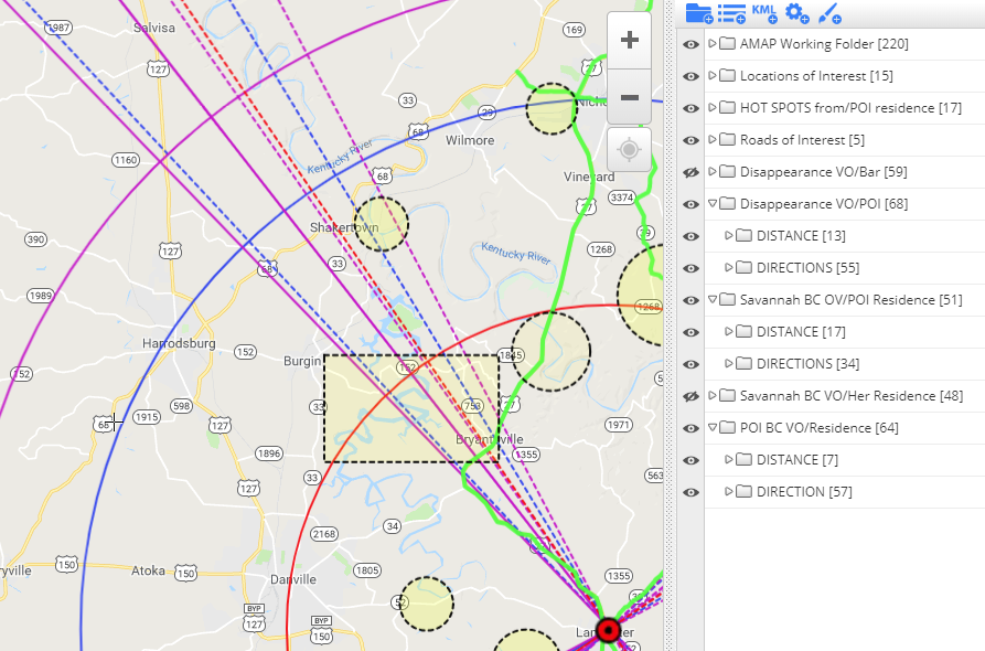 The vectors running over the areas in this image could help to narrow down what parts of the lake and Dix River, and the Kentucky River where a fruitful sonar search for Savannah could happen. Of course depth and other factors would have to be applied, but this area seems that it could hold some promise. As does a few others as illustrated in our map constructed on Savannahs' behalf. Please review it. Perhaps in the scurry to dispose of Savannah, they dropped one of her Shoes, or her Dress---and someone finds something that just doesn't belong---and maybe it leads to a search for Savannah. We have to believe in a miracle, a confession, or a lead of some sort that directs Law Enforcement to the recovery of Savannah Spurlock. Maybe that Miracle will be during PASSOVER.
I can do all things through Christ which strengtheneth me. ~Philippians 4:13 Can this number possibly date the moment in time when we could get Savannah back ---by PASSOVER? Or maybe an arrest? There are other numbers hidden within the planets measurements that could also offer something worthwhile happening this APRIL. Savannahs' name offers us that---APRIL SUN MARKS A NAV ECHO. I believe that is how Sonar works---sending out sound waves and measuring how long it takes for the echo to return. The letters N A and V is the abbreviation for Net Asset Value. Savannah as a mother to her children was an Asset and they don't need to grow up wondering where their mother rests unsettled. Did you know that each year Easter is determined by the Moon? I wonder if Savannahs' knew this? Her name offers that she might, HI! LUNA CAN MARK PASSOVER. If this writing does nothing else, I hope it serves to help the folks in Kentucky and around the States to perhaps understand their own driven desire that is prompting them to get out there and do what they can to find Savannah. Your sensing of an unrest is validated. We are all connected and we are all in this together. I feel certain that if we all believe in the goodness of people during this season of the passion we can get a MIRACLE. Pray someone speaks up. Pray someone pays attention to their surroundings and sees something that doesn't belong. Pray for more CAMERA SNAPS in the area that could of caught the vehicle used to dispose of Savannah. Pray. And then pray again. OK, SAVANNAH---SPUR (a) MIRACLE. We are waiting for you, SAVANNAH MARIE SPURLOCK. A few Dates of Interest in April foretold by the Stars
Longitude grid for Savannah Spurlock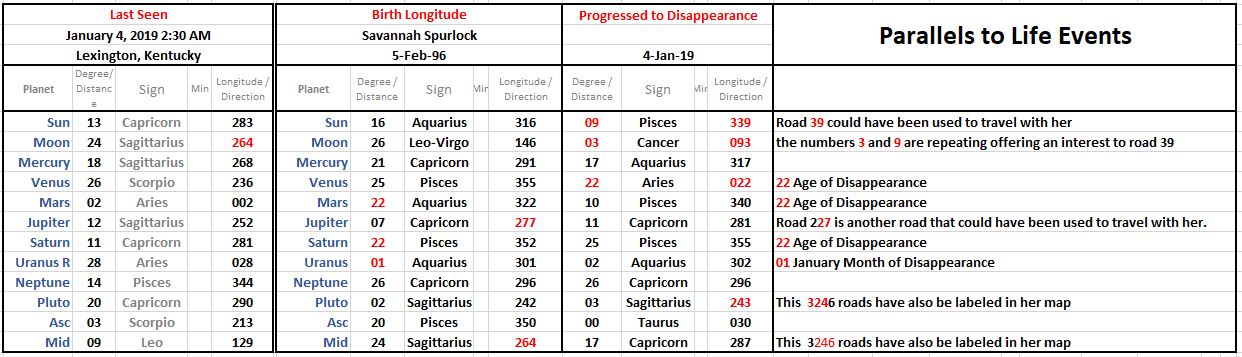
Interactive Map for Casey Hathaway
Syntax Analysis on his name CASEY HATHAWAY
I'm deterred to hot spot his map with experienced insight without having a Date of Birth for Casey, in that I have no way of knowing what aspect at the time of his disappearance was in play and triggering a planet or planetary aspect in his own birth chart; hence the reason why his map will be a work in progress if his date of birth becomes known. Updates below from BIRTH CHART for 1/17/2016 (no time) set for sunrise in Ernul, North Carolina.
The disappearance chart below could offer that at about 15 minutes prior to and after 1:00 PM when the Sun (male) trined the Ascendant (moment) this little could of felt inclined to a walk about. I don't like that his name, CASEY HATHAWAY can rearrange into YA! A HEALTH SWAY. Sort of sends the message that this is not an abduction, but a direct result of being lost from wandering too far.
There is an aspect at disappearance that involved a tight sextile of Saturn and Neptune, with Mars being exactly semi-sextile to Neptune---this could very well describe a stored boat. Mars=Machine, Neptune=water and Saturn=storage or abandonment.
Another rearrangement of his name is, YEAH! H, CASTAWAY ... the H stands for HATHAWAY and that anagram is another indication of something that has to do with boats or marine life. Yet still, I found the anagram HE'S A YACHT AWAY. Perhaps searchers can pay attention to something along this line as they search the surrounding area. Is there a boat storage nearby? Also, I found HAY CASA, WET HAY with no letters left over. So where might there be a barn or shelter where HAY is kept and/or maybe neglected (abandoned), and that's why it is WET. I don't know how clever or resource this little 3 year could be, but I would like to think he at some point went into survival mode and found shelter; If he didn't fall into a water. Water can not be discounted here--ponds and washes are highly likely (birth date update: Mars and Neptune are in a Water Trine) Lastly, I found AHA! YA, C WEST HAY ... does this mean he traveled/walked into a westerly direction? Yes, it very well could. I'm trying to reason that his name might be telling us to pay attention to this aspect in the map we constructed on his behalf; so perhaps searches can walk into this South EAST direction from his grandmothers home, but look WEST for the WET HAY. 3 Days in this weather is a long time for a little one. But his name is also suggesting to me, YA! C HAY AS HEAT with the W left over---could the W stand for West? and could enough dry Hay keep this little one warm? I can also get HAY, HE SAW A CAT ... is this what could of pulled him away from his grandmothers. Seeing a CAT? Who has feral or stray CATS on their property for the mouse population? Check their barns and out houses---look in all the nooks and crannies. I sure hope something written here helps to find little Casey Hathaway.
Update 1/25: This is an image of a Briar patch in the winter---sort of looks like HAY. Sheriff in press conference mention that little Casey was caught up in the Briar.

Updates to Blog Post on Birth Chart
sOME dIRECTIONS OF iNTEREST TO aMAP
The image below highlights the Sun's Square separating from Uranus, but because of his gravitational mass and his position at the top of the chart, its these vectors against the compass that that I think could hold promise for Casey. Little ones most are found on measurements according to both the Sun and Moon. UPDATE FROM BIRTH CHART FOR 1/17/2016 - This aspect is triggered by his own Sun Jupiter Trine and is a very strong possibility for directions.
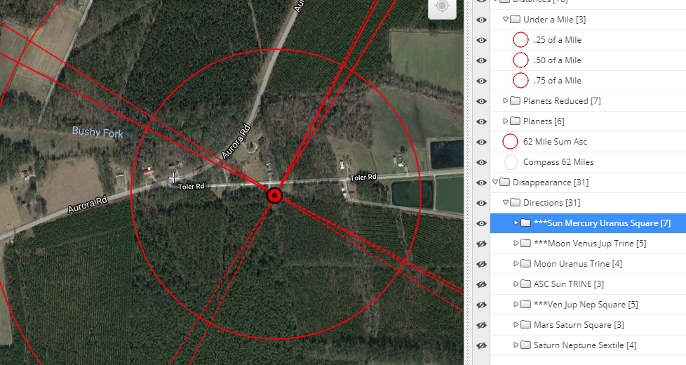
The image below highlights two aspects that are turned on in Casey's map; the Moon Uranus Trine and the Moon Venus Jupiter Trine. Again, little ones tend to be found on aspects that involved Moon or the Sun, or both. ---so again, when searching in directions involving these two aspects that involve the Moon. UPDATE FROM BIRTH CHART FOR 1/17/2016 - this aspect is triggered by his Venus at 22 Sag, and remains a strong possibility.
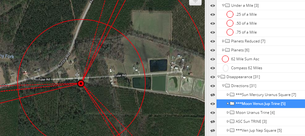
The image below shows the vectors draw for the Venus Jupiter conjunction in trine to Neptune. I highlighted what appears might be a retainer for water. If this is water, and its accessible to a toddle if should be checked. If little Casey was born near the time of early March or early May he very well could have his Sun geometrically aligning with this aspect. UPDATE FROM BIRTH CHART FOR 1/17/2016 - this aspect is forming a trine to his own natal Uranus and could be the tigger to this mishap of him being lost. Could be less potent as the other two above.
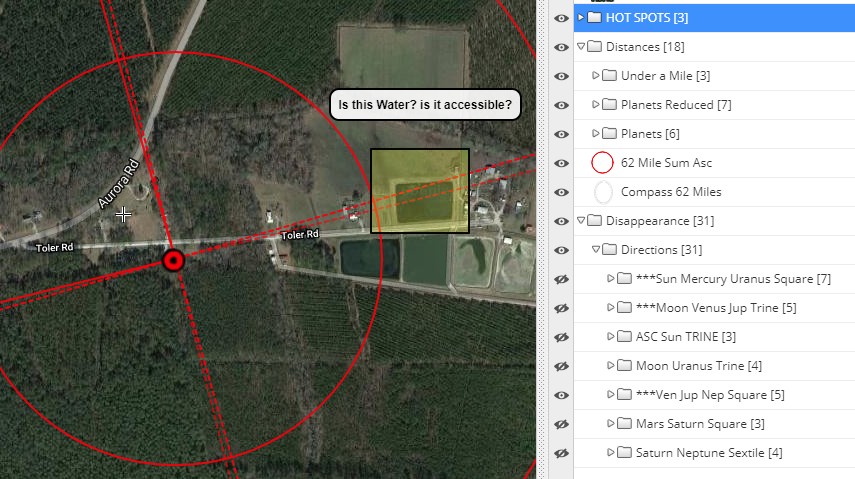
Alexis leaves behind her two year old son and a family that is still searching for her. Below is an Interactive Map constructed on Alexis behalf in an effort to share with searchers in Peoria the potent distances and directions to aim their efforts to recover Alexis Scott. Below our map is our analysis of this predicament.
Interactive Map in the Matter of Alexis Camry Scott
Disappearance Chart
The planetary alignments at the time Alexis was dropped off at the party are a bit disturbing. Mars is ruling the 8th house of death, sex, taxes, and moreover, other peoples' money, while rising at the Ascendant and in sharp applying opposition to Neptune in the house of relationships.
The fact the the Moon is heavily aspected/involved here (chart above) in its Trine to Neptune and its sextile to Mars (and Venus which is not highlighted) suggests to me that there is both a male and female involvement into Alexis' strange disappearance on the 23rd. Furthermore,
It's here where we find the Moon again in Scorpio and interestingly near the very same degree of exact that is was when Alexis left her own home for the last time on the night of September 22nd sometime between 11:30 PM and Midnight as reported by her mother. Below are the two charts side by side for comparison. Below the charts, I examine them both by using just keywords to describe the properties of each planet/light with the sign signature they are in--as they paint a clear picture.
It's here where its a good time to make note again that Alexis' worked as an escort, and her trip to Vegas involved this type of work. So, I just can't dismiss the strong idea that Alexis' disappearance is somehow connected to the events that transpired from the outcome of her trip to Vegas, and her attendance at the party on Richmond. The sighting of the Moon back near to this same degree at two pivotal points in Alexis' life suggests to me the incidents and people involved are related.
As a matter of fact, This sighting brings to mind the cases of Ashley Pond and Miranda Gaddis. Both gals were abducted by the same man, Ward Weaver, while waiting for their school bus. Both girls' remains were recovered from Weavers' home, and both girls went missing during a planetary transit that involved the 18th degree of Capricorn.
When you understand how fleeting the orbits are of the Moon and Venus, seeing this 18th degree of Capricorn, appearing in both disappearance charts of the two missing girls, clearly sent the message to me that these two disappearances could very well suggest the same assailant.
When we finally learned the fates of Ashley and Miranda were at the hands of the man, Ward Weaver; It was also interesting to learn that at Noon on the day of Ward Weavers' 4/6/63 birth, that the Moon measured 18° of Virgo, which as an Earth sign element, would Trine (form a 120° angle) the 18° of Capricorn.
So how do we use all this to help us find Alexis?
Well, we should continue to pay attention to the Stars, both for when Alexis disappeared, and for her birth. Searchers need to pay attention to how both are being transposed over the terrain of the area as illustrated in our map of the Peoria area; and while doing so, keeping mindful of the people involved in regards to where they live, work, frequent, haunt or had cell pings in the hours leading up to and after Alexis was last seen at the party on West Richmond. Alexis Camry Scott Birth Chart - May 20, 1997
Let's take a moment to explore the Birth Chart of Alexis Scott. We need to try and discern if we should be looking for a female who again might be the victim of sex trafficking, or if our search should be for a remains recovery.
Calling a search for remains is one of the most difficult tasks of this work, and trying to do so without an exact time of birth makes the attempt that much more difficult. However, in the case of Alexis Scott, we do have an exact time of birth.
It takes more than just one or two elements to allow me to make the call that a life has ended. First I explore the natal chart (middle wheel) to tell me about the strengths and weaknesses of the lights, the Sun and Moon, which are instrumental to health and life. Then we look at progressions (outer wheel) and then we see what transits (handwritten elements outside wheel) that triggered natal and progressed planets.
Here's what was happening for Alexis.
I remember reading an article long ago on death and the birth chart and the separation of the soul from the body. The writer made cases for noting the planet Jupiter being involved/in apsect at the time of death, which allowed for the soul to find freedom from the body. Alexis, at the time of disappearance, had the planet Jupiter at 26° of Libra forming an exact opposition to her progressed Ascendant (body) at 25° Aries. In light of this, and the notations above, my recommendation would be that a search for Alexis Scott should be for a remains recovery.
Mercury is the ruler of her 4th house and describes the resting place. Gemini rules the house and Mercury in Taurus is involved in a TSquare with the Moon in Scorpio and Uranus in Aquarius. This alignment sort of gives me the image of an area where there is trash and junked cars scattered or even a type of junkyard. Uranus in Aquarius could lend to an area near the railway, and the whole TSquare suggests a places where businesses have been for a long time--but could be abandoned now or not much used. Venus by progression is in her 4th and is in the sign of Cancer and forming a separating trine to her natal Moon so water could be nearby, or the land where she is --is part time dry and part time wet. Which means the area could be alongside creeks and rivers that flood the surrounding area. I don't see a restraint in the water that we keep her hidden--as could be, if there was an offering aspect from Saturn in her birth chart. The Gemini connotation of the 4th house cusp suggests open land, but could very well be on private property---because of Mercury's placement in Taurus. Syntax of the name - ALEXIS CAMRY SCOTT
I will be exploring the wealth of words that can be born of the name ALEXIS CAMRY SCOTT. I am hoping one of them will tell us more details about where she may rest. We already know that she went to Las Vegas to work for a few days as "eye candy for a bachlor party" that somehow got canceled, according to her mothers interview with The Vanished podcast. Her name tells us, LAS CITY, AM ESCORT X.
It's clear that who ever arranged this trip to Vegas did not look out for Alexis' best interest when she was later found nude rolled up in a ball by strangers in Sacramento, California. But she somehow made it out of alive from that very disturbing incident, and her name tells it like this, SOS! TY! CA MIRACLE with just the letters T and X left over. The TY could stand Thank You as she was grateful for the strangers who found her and helped her get back home. As a matter of fact, all the letters that spell out the city of SACRAME(n)TO live in the name of ALEXIS CAMRY SCOTT, except for the letter n; and with the remaining letters, her name can tell us, LY SIC SACREME(n)TO with the letters X and T again left over. We learned from Alexis' Mom how she was found by strangers who helped her get clothes and get back home. These truth hidden inside her name are helping me to feel confident that her name just might tell us more truths about where she could be---so let's move in that direction. But before we do that, one of the girls who went on the trip to Vegas with Alexis, I saw from another post on her Facebook page, was a gal called Razja MARIE; the name MARIE can be anchored from ALEXIS CAMRY SCOTT to form the anagram, MARIE'S X ACT COSTLY. Aren't friends suppose to look out for one another---especially in the escort business, and when your far from home? How did Alexis' fall out of sight of her friend Razja MARIE in Vegas that she woke up in front of strangers in California? Alexis tells us C Y MARIE ACTS LOST with the X left over. C is See and Y is Why. Interesting. I like that we have the words MARS, LOCATE, and MILES in her name. It helps me to believe that perhaps her name will tell us what star to pay attention too when looking for her. Look at the following anagrams I found anchoring and using the word MARS from her name.
Is her name actually telling us to look at a distance that is in accordance to Scorpio, the sign that rules over TAXES? The Moon was in Scorpio at her birth and at her disappearance---if we go 4 to 5 miles out in the South East direction which involves the TSquare of MARS, there is a junk yard near what appears to be a creek that runs down Cole Street. See the image below. Has the Cole Street / Springfield Road area ever been searched? You can view this area in better detail when you Interact with Map.
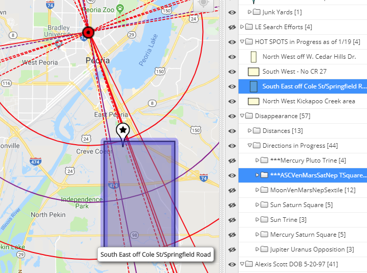
other Possible areas to Search
There is a good chance that the distance to remains could be further, as offered by Mars' measurement at her birth and at her disappearance being 19 and 11 degrees of Virgo. The possible distances can be turned on (and off) in our map, and the vectors for the aspects should be considered alongside what is known about the people involved. But I would check Cole Street, immediately.
From experience, it not unlikely that someone could dispose of evidence in one direction, while they dispose of remains in another. A good example of this is in the matter of Jessica Runions. Her car was found burnt in the direction of one aspect, while her remains were found in another direction indicated by a different aspect. If the burning of a mattress and rug that happened somewhere in Canton is in fact related to the disappearance of Alexis---then the South East direction of Cole Street would seem like a likely alternative direction to dispose of Alexis. It should be checked. I read through the timeline of Alexis' disappearance and it offered areas near Route 24 that were searched by LE. I mapped them in Alexis' interactive map. Perhaps the vectors in our map could offer a tighter alignment into those areas surrounding. Our maps are not magic, they must be considerred alongside acute knowledge of the area and the intel that unfolds during an investigation.
On an ending note, tonight we will have a total Lunar Eclipse of the Moon. And its happening at the 0° Leo and Aquarius axis which will Trine the Sun at 0° Libra for when Alexis was drop off on West Richmond. Eclipses have a tendency of making things come to a head.
I'm hopeful that this particular eclipse, which will also complete the MoonMercuryUranus Fixed TSquare into a Grand Square that Alexis' has in her own birth chart, which as I already mentioned in this writing, holds rulership over her resting place; will be what gives this case a little shake. This eclipse could be just what the case needs to get things stirring in Alexis' favor. It's time Alexis is brought home.
Sources
Update: Remains recovered 11/27/18 off Wiregrass Rd in Orrum, North Carolina.
The Sun Neptune trine at the time of this crime strongly suggests Hania's abductor could be homeless and/or drug addicted. Please, check to see if any vectored planetary patterns in our map move over abandoned homes or even churches connected to wooded lots. I bring the idea of abandoned homes and churches up because Hania at her birth has a Moon Neptune opposition---this is a planetary signature that suggests remains recovery could incline near to abandoned homes or businesses, and/or near Churches. For example, Florida's Cherish Perwinkle was found behind a church, while South Carolina's Iyana Lowery was assaulted behind an abandoned home and left only a few feet nearby. Both had strongly tightened Moon Neptune aspects at their birth---both cases can be viewed on our case study page. In my opinion, this writer is not seeing enough planetary elements at the time of disappearance that would trigger and suggest a passing of life on the day of abduction for Hania, but more of an abduction/disappearance for companionship ---which leads me to temper the possibility that she could be alive, or at the least held for a day or two. Our map has been vectored for a 50 miles radius around her home. (Special Note: They could be extended if investigation leads outside of 50 miles.) Patterns could show where she is and/or where she was being held and/or where remains could be recovered by way of several different patterns. For instance, In the image of AMAP's interactive map below, the measurements of the Moon Pluto Square at the time of the abduction vectored over her home align very near to where the family vehicle was recovered. 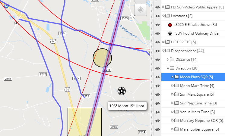 This image above should be the encouragement to consider the map elements to plan a search effort. The family vehicle (black star in white circle) involved in Hania's abduction was found
Let me suggest here that there should be interest focused also on areas that are about 8 to 9 miles away in this same direction being offered by the Moon Pluto pattern; as Hania's has her own Uranus at birth is measuring 8 degrees of Pisces and there is a good chance her Moon and progressed Mars could put her at or near to that distance as well. Please see interactive map for all potent directions. Interactive Map for whereabouts
Hania Aguilar birth Chart
If I want to know more about the male person responsible for this abduction my eye is trained to look closely at the Sun and Mars sign placement and aspects at her birth. Hania has her Sun 00° Aries and her Mars 00° Aquarius and so this describes him as an aggressive (Aries) stranger or acquaintance (Aquarius)---the sextile the Sun and Mars form with each other however could suggest she does know him from some connection through family, a friend or the community. It also suggests he is most likely medium in build and medium in height with hair dark tight to the head. Eye color could be green or blue with a strong squared jaw line. Her natal Jupiter is in opposition to her natal Mercury in Aries and both are making their respective Trines and sextiles to the planet Neptune, and being triggered by the progressed Sun could very well suggest death but its my opinion it came a day or two after the abduction with the Moon's transit through Scorpio triggering Hania's progressed Moon conjunct natal Mars. Syntax of the Name
If her name can tell us this truth of her own Moon sign being deposited in the sign of Leo at birth, which is based on the mathematics of the astronomical process, in which it takes the Moon about 2 1/2 days to make its transit through Leo, this message in her name is uncannily eerie. This particular anagram of her name cannot be chalked up to coincidence. The only problem for us is ----which Moon LUNAR LINE is being expressed in her name? The Moon in Libra at disappearance, which again, have vectors align near to where the family car was found; Or, do we look to the Moon in Leo at her birth which can be roughly viewed in the map immediately above and reflects her Moon Neptune opposition. All patterns the Moon made at birth and at disappearance have been vectored and can be viewed and interacted with in Hania's interactive map. I'm going to make the mental leap here and claim, that Hania's own name is giving us clear directions to keep our attention on areas that are falling on and near to a vectored line/lines that involves the Moon. So my suggestion is too pay attention to both; and pay attention to areas in all directions of the compass, since its quite possible where the assailant talk Hania to spend time with her could either be in the same direction as where the car was found, or it could be in one of the another compass directions as illustrated in the geometric pattern vectored, The map image below illustrates the Mercury Neptune Square that was present at the disappearance, and the southwest vectors are aligning into the area where the FBI has captured a person of interest walking and making his way towards Hania's mobile home park (yellow paddles). I'm not saying that the person in the video surveillance is responsible for this, but these vectors heading there could offer her assailant as coming from that direction. 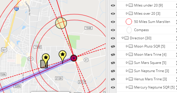 Mercury Neptune Square (click to enlarge image) Her name, HANIA NOELIA AGUILAR, can also tell us, O! HE'LL RUIN AGAIN, I AAA and HAIL! I A LUNA GONE ARIA. I am not sure what the AAA could stand for, except perhaps for road service? An ARIA is a song for a solo voice --maybe this anagram is suggesting she is not among other girls and this not sex trafficking. LUNA is feminine in nature because of its connection to the Moon. Women know well the 29 day menses cycles, and it takes the Moon just about 29 days to make one complete orbit of the zodiac. 'As above, so below'.
I don't like that the words LONG HAUL can also be made of her name ---and with them I can form the anagram, I IN A LONG HAUL AREA. These words are offering the image of a truck stop of sorts or perhaps some sort of distribution center or even gas service station. Again, check our map against abandoned homes and businesses, especially those that deal with trucking distribution---these places could very well be near to the rail ---since Hania's own Moon and Mars at birth are transiting the sign of Aquarius which has ruler ship over the railroad. This line of thinking is troubling and has me considering the idea of sex trafficking, but the stars at her birth suggest a passing that occurred a day or two after her abduction. So I'm wondering if her assailant might of hid himself with her near areas of this ilk---again perhaps they are abandoned and he knows about them because he is homeless. In effort to keep looking at this idea, I found I IN A HAUL AREA ALONG I ---the I could stand for Interstate. There are other troubling words that can be born of Hania's name such as NON-LEGAL and NEGRO. But Lets face it, 5 consonants and all the vowels are in her name, HANIA NOELIA AGUILAR---making it an extremely difficult name to lex using this syntax method because of the amount of words that can be born of her name---so it's important that I stay constrained to only the words that are troubling to me, and those that offer could offer a description to her predicament right now. If you are are reading this and there in the Lumberton, North Carolina region and could be part of a search effort, perhaps you can use our map knowing that where such types of areas exists. I am hopeful LE will get a good solid lead soon since the word RE-UNION lives within her name, but the word HEARING also lives there, and to me it suggests LE will get this guy. This effort by AMAP was done with the intention that it may serve as help in locating Hania Aguilar. I will continue to work with her name and may up-date this writing if I find anything else of value.
Below is a screen shot that reflects the exact square that the Moon and Neptune were forming at 5:30 AM when Karlie stepmom says she last saw Karlie in her bed on Saturday morning October 13, 2018. The two hotspots are two areas where I would do a search for Karlie right now if i were in the Bishop area.
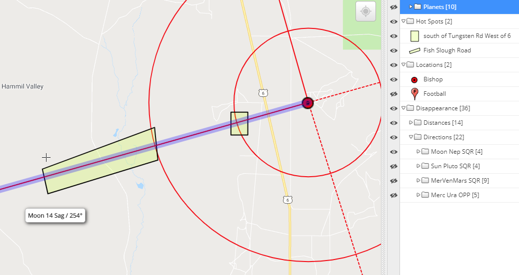
Syntax of words for KARLIE LAIN GUSE
The name KARLIE LAIN GUSE has the words LUG SKI AREA LINE. This syntax of words that can be born of her name suggests to me that someone carried her into a direction (LINE) where people travel to ski. Was Karlie a skier? If yes, dismiss this anagram. But if not, a quick check of the area for ski resorts returned a few of them in alignment with planetary patterns. One in particular is the Round Valley area ---this location aligns with the Moon at the time of her disappearance runs right through that area, while in another pattern there is alignment towards Benton, which has ski resorts to its West. This doesn't mean she is that far from her home. Yes, it possible and the areas hot spotted, but I'm wondering more if this syntax of words is just requesting that we pay attention to specific lines in our map that are closer in distance to her home. See our map below for more of those areas.
Also the Sun and Pluto's pattern, it also has ski resorts near the Sun line---so this line and the areas it aligns into should be considered. One of the other anagrams I found using the word SUN, is I K, LIE A REGAL SUN --the K is her name, Karlie. (see map below) I thought it odd that her name would tell us, LIAR USE LINKAGE, which sort of sends the message to me that some of what is being told about the last moments with Karlie could very well be fabricated but with some woven threads of truth. It's troubling to also find I SLAIN, URGE LAKE or I SLAIN GRUE LAKE, as it suggests she is deceased and could be near to an area that has a lake or perhaps on a road that would take you to a lake. What happens when we anchor the word LAKE, I can the words that might be suggesting there is nothing pleasing about this LAKE, when you syntax the words, EG, LAKE IS URINAL. So could this body of water of something to do with a waste type of feed from another source? Keep this in mind. Scary part is her step-mom, MELISSA GUSE, can re-arrange into EE! LUG A MISS which kind of sort suggests she struggled to carried a young girl. Another trouble find was USE SAG MILES. What the heck!, MELISSA GUSE, "...the Moon was 14 degrees of 'SAGittarius' when you said you last saw Karlie at 5:30 AM". 14 miles puts out by the Ski resorts that are south from her home and near both the Round Valley area and the Coyote Valley Road area. MILES A GUESS is another anagram of her name ... which makes me think she will soon bend to LE and tell them a different story; Or, LE will find a clue in the purchase of Gas and its usage during the time of Karlie's disappearance. I'd like to think they've already considered this deduction for the development of their own time line, because of the anagram LE MISUSE GAS is another re-arrangement of the letters of her name. Perhaps something isn't going to add up? Plus, The anagram E! SLAMS GUISE sort gives the hint of what is happening with her personalize videos of desperate measures to get the word out about Karlie's disappearance. And lastly, GUILES A MESS is surely suggests deception. If I go back to the word LUG, and anchor it, it tells me I LUG MESS, SEA. That's a water source? whether it be a Lake, or Creek or River. So my thinking is that a search effort for Karlie needs to focus close to water such water sources that are in direct distance of 14 miles away. Melissa Guse's name doesn't suggest she is the one who hurt, Karlie. I wondering if she is covering for someone? One more thought I would like to bring up and that is the Moon Neptune Square at the time of her disappearance ---this aspect could direct towards water, it also suggests abandoned homes and churches--so keep this in mind while searching. Updated 2/21/2019 - I played a bit more with Karlie's name while adding her birth vectors to her map. I found, I GUNS KILL AREA. with the E left over, could it stand for EAST? Sort of gave me the idea of a 'gun range' or 'a hunting area where guns are used'. I have no hot spots in the south east, but is there a place where folks go to shoot their guns for fun South East of her home towards the mountains? I don't want to take attention off of Ski areas, just wondering if we need to think of place along the way where GUNS are used for sport. I found GUN SKILL AREA with the letters I and E left over. Which could mean I, East, SKILL GUN AREA. The E could stand for something else. I know, its frustrating, but keeping the words GUN AREA anchored, we are still being directing towards something, I ELL SKI GUN AREA. The word ELL is typically used in measurements---and/or the L shape--as the tool. I highlighted a place near June Lake that has a gun range. This gun range is in alignment with the Mercury Uranus opposition at the time of her disappearance---and is a some 2 1/2 hour drive right up 395. Is there a time range that makes this drive distance a possibility? Karlie's own Moon Mercury Neptune Trine takes up that way as well. 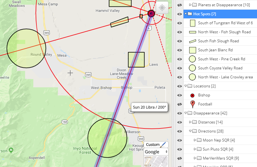
How to Use the Interactive map for karlie Guse
Help Us Help Others Find Their Missing
Works Cited in the case of Karlie Lain Guse
This Writing and Interactive Map are both in Progress as of October 19, 2018
Baby Arieanna's father Andrew Christopher Terry has just been released on bond for charges of disposing of a body. Perhaps our Interactive Map constructed on Baby Arieanna's behalf will help target potent areas to plan search efforts. Our maps are not magic, they need to be intelligently considered alongside sound investigative procedure and knowledge of the area and all persons of interest involved so that attention can focus on those areas where vectored planetary patterns are offering potent directions for recovery.
Below is an screen shot image taken from our interactive map showing the southwest direction from point of disappearance with areas hot spotted that are near to water and the rail tracks as reflected by the Sun Neptune Opposition at the time of her disappearance. There are other planetary patterns that need to be considered. This image is just one of them that appeared to be potent based on the fact that rail tracks are running along the river in this direction. If I was there in Roanoke I would check these areas first as highlighted in these two maps below. Our interactive map to explore these areas in a closer look is below. 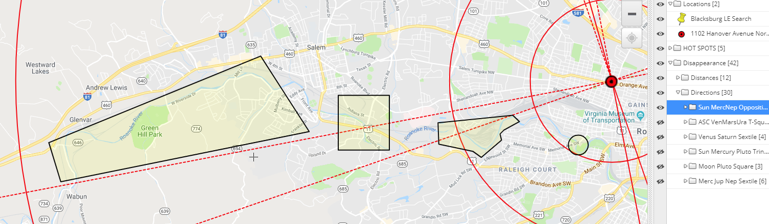
The map below reflects Terry's own Sun vectored (blue line) into the South East area of town near 9th Street SE. The red and pink vectored ley lines are those belonging to Baby Arieanna at birth, and at the disappearance that reflect a triggered a T-Square involving Mars at birth at her disappearance.
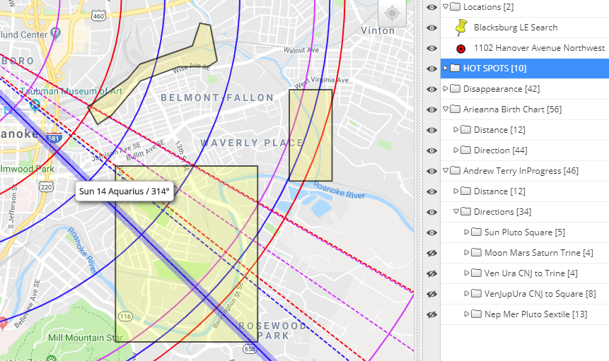
Searching for clues in his name ANDREW CHRISTOPHER TERRY I found the troublin' anagram THREW HER CORPSE DRY TRAIN. So this might be telling us that she is not submerged in the water but near rail tracks. Here is another anagram that suggests the area is dry and not wet, HE THREW ARIE DRY RR SPOT with the letter C and N left over, could they mean C (see) N (north or near).
I also found TYRANT HIDE HER CORPSE RR with a W left over that could suggest a direction that is West. WE HIDE HER, C RR TRANSPORT with a Y left over is another disturbing find. Is there road access to areas near the railroad tracks that also have surrounding wooded areas for a disposal? The area could certainly be industrial in nature during the day. YES!, WE HIDE TOT RR CAR ... is just one more way of saying the same thing still using all the letters of his name, ANDREW CHRISTOPHER TERRY. Might be a good idea to learn where this guy worked in the past to see if those places of interest are in directions that also point into areas that are near to or have to do with the railroad. The words, HER ROAD INTERSECT PH RR with the letters W and Y left over could suggest that we need to look at water that is being crossed by the rail tracks. PH is something that we test in water, while the W could stand for West, but unsure about what the Y. Most disturbing find is, THREW ARIE CORPSE NTH RR YD with no letters left over. Everything about this man's connection with a missing baby is telling us we need to set our sites near areas that have to do with the Rail Road. It's important that it is understood these words from his name can be consider against all distances from point of disappearance against roadways that pass over or nearby the railway and the places that have something to do with the Rail Road. So consider our map with what you know of the area, and the possible roads he might of traveled to get from Roanoke to Blacksburg. Is there a known open time window from the time he took Baby Arieanna to his arrival in Blacksburg? Does the time line add up, or is there a time span when he could of rested somewhere secluded with Baby Arieanna in the Roanoke area? or along the way to the Blacksburg area?
However, Baby Arieanna lived on the corner of Hanover Avenue, NW and 11th Street. So I'm wondering if Terry used this road to exit the area? The fact the south end of 11th Street ends at the Rail yard on Shenandoah Avenue is troubling to me? Any place off this road where he could of pulled into and remain unnoticed? How familiar is Terry to this area, where did he live? where did he work? What roads would be a familiar ride to this creep? Look to see if any of the vectors in our planetary patterns in our Interactive align to areas of interest connected to Terry.
Baby Arieanna could very well be some 27 miles from her residence which would be in accordance to her own Mercury at 27 Leo which would put her in the area where police are now searching. I have highlighted these two words TRANSPORT and RESEARCH in the previous paragraph because they both can be born of his name---ANDREW CHRISTOPHER TERRY. So, if LE has good in-tel that they should be looking into this area, than perhaps his name is narrowing down the area to this specific road where there are rail tracks are moving over it. You can click on the above map to enlarge it, or you can use the interactive map below.
Syntax of words in the name ARIEANNA RENEE DAY (still in progress as of 10/19/18)
Interactive Map for Whereabouts
Help Us Help Others find Their Missing
Works Cited
UPDATE 5/15/20: On April 28, 2020 Greene County Sheriff Gene Fishcer reported that over the weekend the remains of Cheryl Coker had been found in a field by mushroom hunter near the 1200 Block of Waynesville Jamestown Road.
AMAP vectored this area to be at 129° / 9° Leo compass bearing at 15.7 miles from her residence. From her resident this area is highlighted to be in the direction of the finishing point to the vectored Venus Mars Uranus TSquare that was present at the time of her disappearance. 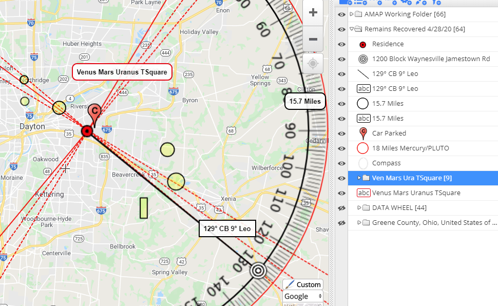
No birth data for Cheryl has been obtained so therefore no birth chart has been analyzed for more information; however the Mercury Pluto square at the time of this disappearance inclines my opinion to lean towards the idea that a search should be for remains---with a heavy focus put on watery elements near wooded areas but also something social in nature. I would tend to favor creeks being the Moon is in Cancer. Below are two maps of area that in our opinion could hold promise for a recovery. But understand our ideas are not limited to the areas depicted in the two maps below--further down you will be able to explore and interact with the whole map; which, as always, needs to be considered against what is coming to light in the investigation alongside acute knowledge of the surrounding area.
In the meantime, the two maps below could serve to show our immediate findings as we work.
North East
Personally I favor a distance at 6 miles, but I don't think she will be any less that 3 miles away from her residence, and not more than 39 miles away. The image below shows a hot spot at a 3 miles distance in accordance to the Sun Mars Trine
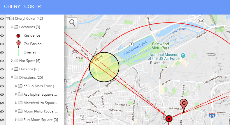
South East
In the map below, two patterns have been turn on to support the area hot spotted in the about map, but to also offer a potent direction that is South East from her residence with hot spots that are 6 miles out near Fairground Road and Beaver Valley Road.
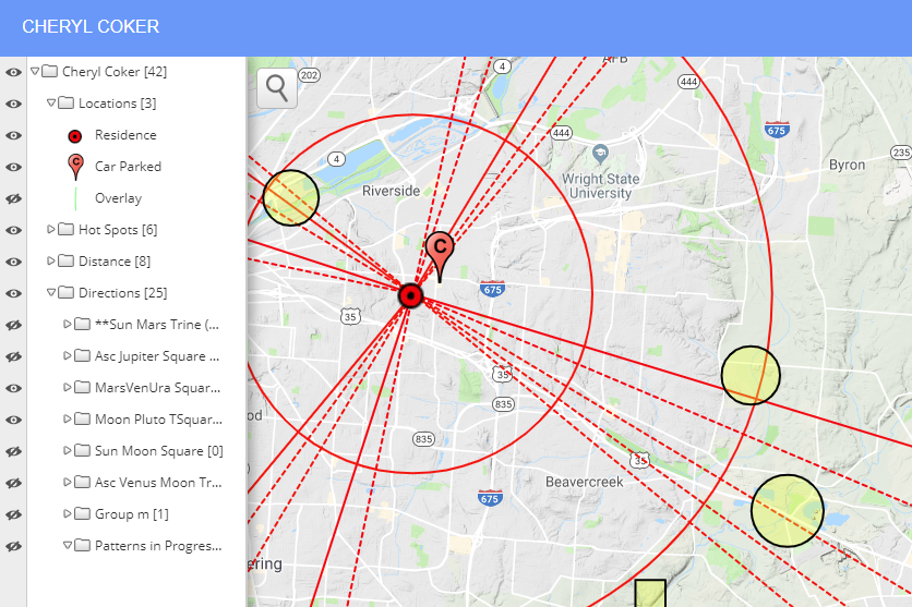
Interactive Map for Cheryl Coker
Sadly the name, MADDOX SCOTT RITCH, has the words STORM DITCH in his name. And with the letters left over, the rest of them constrain quite evenly to form the troubling anagram, that suggest we might want to look for X AT DOC STORM DITCH.
More troubling is that when we anchor the word MARS from his name MADDOX SCOTT RITCH, there is a profound anagram that tells us, C X, C HID TOT MARS DOT. The dotted lines you see extending out into the South East of Rankin Lake Park are those of the planets MARS' pattern in its TSquare angle that it was making with the planets Venus and Uranus at the time of his disappearance.
What makes this alarming to us here at AMAP is that we use dotted lines to show that these lines are considering as finishing points/angles for the planets measurements against the compass. Another troubling sighting is that over near this Dr. MLK Jr. Way is what is known as the Norfolk Southern Railroad Train which is pretty close by to the railroad tracks and what looks like a canal or creek running along Dr. MLK Jr. Way. Uranus is the planet that rules the railroad and it is involved is this patterned angle. Please go check in and around the area that is highlighted in yellow on our map. It can't hurt to just go look. There are other highlighted hot spots in our interactive map constructed on his behalf but if I where there in Gastonia right now I would be giving the area over off of Dr. M.L.K. Jr. Way a really good look. Link to our work on Maddox Scott Ritch |

AMAP FOUNDERS
April Gonzalez / Renee Francis If you are here because you are seeking help with a missing person case please use the chat window to reach out to us when we are online.
AMAP funds and supports all Interactive Maps for all missing child cases, as well as the cost for keeping this site available to educate the public on the findings from our study. AMAP
|